-
アジア航測 ホーム
- 災害関連情報
-
2016 Kumamoto Earthquake (English)
2016 Kumamoto Earthquake (English)
2016/06/14

|
2016 Kumamoto Earthquake
|
|
We present our deepest condolences to those who lost loved ones in the earthquakes, and also to express our sympathy to all who were affected in Kumamoto and Oita prefecture, Kyusyu.
April 14, 2016 at PM 9:26 (local time), a M6.5 earthquake (JMA Seismic Intensity-Upper 6 at max) occurred in an epicenter located directly beneath the city of Kumamoto. After the quake, April 16 at AM 1:25, a M7.3 earthquake (JMA Seismic Intensity-7) occurred again.
The Japan Meteorological Agency (JMA) revised the first quake was the foreshock earthquake and the second one was the main shock. Even now (April 22), there are lasting many aftershocks.
Asia Air Survey implemented an emergency observation at damaged areas. The information is opened to the public through our homepage in free. We highly hope our technology is useful for constraining the second disaster and understanding the quake’s mechanism.
Update: June, 14, 2016
|
| ■An approach of crustal deformation analysis based on comparison of two periods of Lidar measurement |
|
Asia Air Survey, Co., Ltd. took Airborne Lidar measurement on April 15, 2016 for confirm the seismic surface fault after the earthquake occurred on April 14.
The expected mainshock struck in the early morning of April 16, and we confirmed seismic surface fault appeared in the same area where we have taken Lidar measurement on April 15. So we decided to take another Lidar measurement on April 23, along the same courses, using same airplane and same sensors of the measurement of April 15.
Based on the results from two period’s measurement, we confirmed seismic surface fault and detected very small deformation of the fault.
|
|
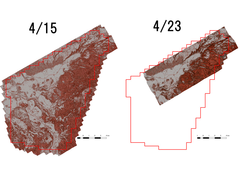
Fig.1 Lidar measurement area before and after the mainshock of the Kumamoto Earthquake
|
|
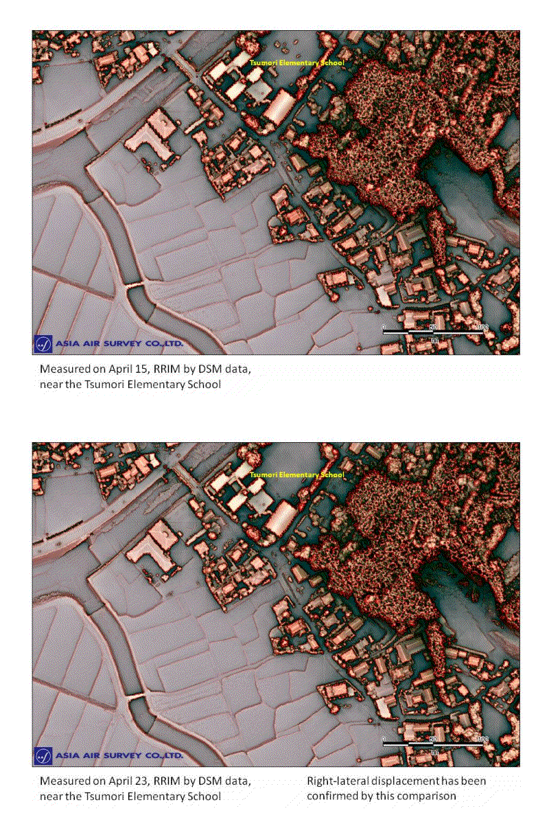
Fig.2 Comparison of Red Relief Image Maps created by Lidar data of April 15 and 23 (Near Tsumori Elementary School of Kamijin, Masuki Town)
A very clear right-lateral displacement can be recognized along the central part of the study area, as the upper (north) side is moving right (east) direction compared to the lower (south) side.
|
|
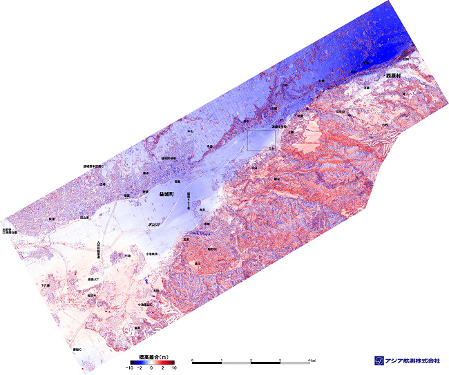
Fig.3 Differential map in a large area
We tried to show height differences between the two period’s data by color expression. In this map, the height differences of minus 10 m, minus 2 m and 0 m were expressed by indigo, blue and white, respectively, while plus 10 m and 2 m were expressed by red and black, respectively. The differential map was shown as Fig.3. In the case of house damages, especially the fully destroyed houses will cause minus several m, so it will be expressed as blue color in this map. The map shows tendency of the blue colored area was concentrated in specific narrow zones. Seismic surface fault was recognized in flat area in the central part of the map, also along the border of flat area and hill area. In the northern part of the Mitake area, Mashikimachi near the center of the map (rectangle in the Fig.3), we found two parallel faults and another fault crossing the former two, and checked the deformation after enlarging the map.
|
|
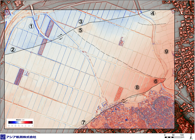
Fig.4, Overlapped map of RRIM and differential map (the white color is expressed by minus 0.8 m for easy to understand the relationship between differential amount and color).
According to blue color appeared in the western side and red color appeared in the eastern side of the embankment near ①, the deformation is considered to be from west to east direction. This moving tendency also can be recognized from the paddy banks near the embankment. From the width of the blue colored part caused by deformation was being smaller in the southern part of the fault line marked by ②③④, the fault was considered to be a right-lateral one. The vertical deformation is downward in the northern part near ②③, but relative difference of height was not recognized from ③ to ④. A fault can be confirmed from ⑤ to ⑥. The paddy banks in the southern side of the fault were blue colored but no blue colored part appeared in the northern side. According to this characteristics, the fault between ⑤ and ⑥ can be seen as a left-lateral one. A local uplift can be recognized near ⑤⑥. In the southern side of the fault of ⑦~⑧, according to the blue color was appeared in the eastern side of the houses while red color appeared in western side, the fault can be considered a right-lateral one. In the northern side of the fault, a downward deformation was confirmed near ⑦ and uplift confirmed near ⑧. Because no deformation was confirmed near ⑨ in the two sides of paddy banks, nearly no horizontal deformation was existed.
|
|
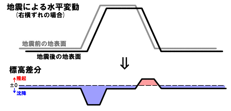
Fig.5 A method to interpret movement of strike-slip fault from differential map
In the case of a trapezoid north-south directed road embankment moved from west to east, minus displacement will be appeared in the western part while plus displacement will be appeared in the eastern part in the differential map. It is possible to know horizontal movement from such a vertical displacement. However, it must be notable that amount of displacement is expressed by color but not related to the depth of colors.
|
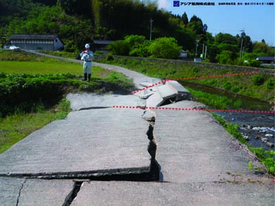 |
(a)Photo No.6695
Near the junction of two faults (near ⑥)。River Revetment structure has been destroyed by fault movement.
|
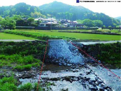 |
(b)Photo No.6691
The above (a) seen from opposite bank from river.
River Revetment structure was uplifted due to two faults.
|
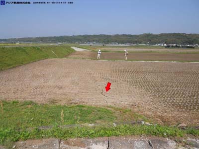 |
(c)Photo No.6690
The left side looking to photo is being higher.
|
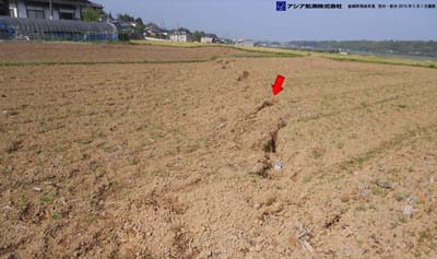 |
(d)Photo No.6687
A series of left-stepping ruptures were appeared and showing the right-lateral faulting.
|
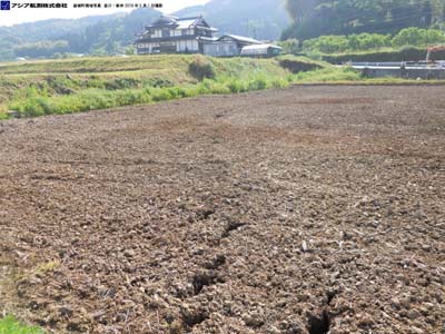 |
(e)Photo No.6685
A series of left-stepping ruptures were appeared and showing the right-lateral faulting.
|
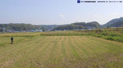 |
(f)Photo No.6683
The remained rice plants was displaced systematically to right along the line in the center of the photo (left-right line), while the front side was displaced to left, showing the right-lateral faulting.
|
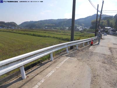 |
(h)Photo No.6678
The fault was recognized as right-lateral one based on the deformation of road and its guard rail due to the fault crossing the paved road.
|
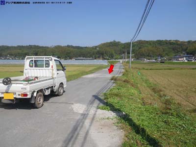 |
(j)Photo No.6702
Right-lateral displacement observed across road.
|
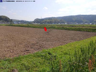 |
(k)Photo No.6700
The right side looking to photo is being higher. A series of left-stepping ruptures were appeared and showing the right-lateral faulting.
|
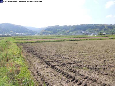 |
(l)Photo No.6701
A right-lateral fault was estimated according to en echelon ruptures.
|
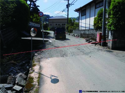 |
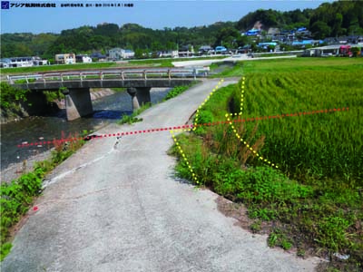
(o)Photo No.6719
The waterway revetment was displaced right-laterally. The waterway revetment in the left side in the picture was destroyed seriously.
|
 |
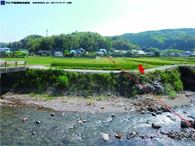
(p)Photo No.6705
Right-lateral displacement of vegetable and rice plants along the road.
|
 |
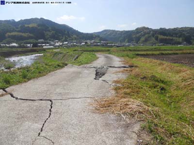
(q)Photo No.6707
River revetment was seriously destroyed where the surface faulting occurred.
|
 |
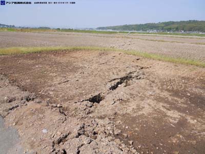
(r)Photo No.6708
The opposite side of photo (q), shows the damage of road in the left bank of the river.
|
 |
(s)Photo No.6710
The fault clearly detected by the Lidar measurement of April 23.
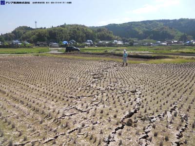
A series of left-stepping ruptures were appeared and showing the right-lateral faulting.
|
 |
(t)Photo No.6711
The fault clearly detected by the Lidar measurement of April 23. A series of left-stepping ruptures were appeared and showing the right-lateral faulting.
|
| About this page |
-
On this page are posted the results of photography carried out independently by AAS.
-
Enquiries regarding the image data should be directed to the address given below.
-
Please make your enquiry via e-mail.
-
E-mail: service@ajiko.co.jp
Regarding Secondary Use of Disaster Area Monitoring Images
-
Please send in by fax, mail or e-mail your application for a license to use the photographic images.
-
The license will be sent to you following a review of your application.
-
-A fee for use may be charged, depending on in what form and for what purpose the images are to be used.
-
-Use of the images without a license or violation of the content of the application may lead to cancellation of the license or a claim for damages.
-
-Images used must be clearly marked "Photograph supplied by Asia Air Survey Co., Ltd.
-
-Please send to AAS some indication of the form in which the images have been used (original, copy, photograph, URL, etc.)
-
-Please let us know whether the results of your research can be published on the AAS website.
-
Disaster Photograph/Disaster Area Monitor Photograph Manager,
-
Head Office Management Operations Dept.,
-
Asia Air Survey Co., Ltd.,
-
Shinyuri 21 Building, 1-2-2 Manpukuji, Asao-ku, Kawasaki-shi, Kanagawa Prefecture 215-0004
-
FAX: +81-(0)44-965-0040 E-mail: service@ajiko.co.jp
Copyright
-
Asia Air Survey Co., Ltd., holds the copyright to all text and images published on this page. Information obtained from this page must not be reproduced, sold, published or broadcast without permission.
Disclaimer
AAS has taken every care to ensure that the information offered on this page is accurate; however we take no responsibility for the accuracy or validity of the content of the information. Please contact us if you have noticed anything that is clearly inaccurate, so that it can be corrected/deleted.
|
すべて見る
- アジア航測 ホーム
- 災害関連情報
- 2016 Kumamoto Earthquake (English)


