- HOME
- SERVICES and PRODUCTS
- Disaster Management
Disaster Management
Planning and design flood control and SABO structures, Hazard Map, Disaster Resilience Education
- SABO Works - Erosion control consulting
- Volcanic SABO Works - Volcanic disaster prevention consulting
- River Basin Management - River disaster prevention consulting
- Regional Plan for Disaster Prevention
Case Studies
Risk Management Planning based on the Simulation of Landslide Dam Outburst
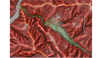
Using Airborne LiDAR technology and Landslide dam outburst simulation, AAS estimated the disaster risk areas by deep-seated landslide induced debris flow formation and outburst of natural dam. Based on analyzing results in advance, AAS discussed countermeasure for the expected disasters. Read more(Japanese version only. ) →
Volcanic Hazard Map of Mt. Hakkoda
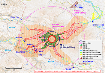
AAS took part in the creation of hazard mapping of Mt. Hakkoda eruption for the purpose of disaster prevention. The hazard map of Mt. Hakkoda includes the disaster area estimated by the simulation of ballistic block ash fall, lava flow, pyroclastic flow, snowmelt induced mudflow and debris flow after ash fall. AAS estimated the hazards based on the topographical conditions and previous examples, such as the eruption of Mt. Unzen and Mt. Usu. Read more(Japanese version only. ) →
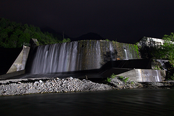
Maintenance Plan of Historical Sabo Facilities
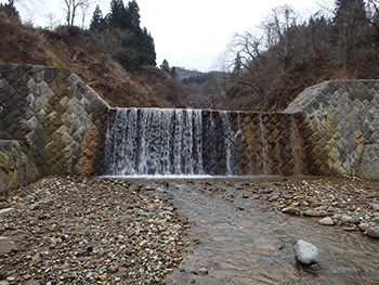
Among those historical Sabo facilities which had been constructed 50 years but still have historical and cultural values, AAS conducted investigation into the deteriorated and damaged ones and provided repair plan for them. Historical Sabo facilities have different features in material, structure, size and construction method depending on regional characteristics and economic background. Upon long-term use of the facilities, we took into account these features and analyzed the damage factors and discussed the maintenance plan. Read more(Japanese version only. ) →
- Related product