- HOME
- SERVICES and PRODUCTS
- Geospatial Survey
Geospatial Survey
Airborne and space-borne remote sensing, and vehicle-mounted laser scanning surveys
- Space-borne Remote Sensing
- Aerial photography(Vertical /Oblique)
- Airborne LiDAR Surveying(Airborne LiDAR Mapping /Airborne LiDAR Bathymetry)
- Mobile LiDAR Surveying(Mobile Mapping System )
- UAV Aerial Surveying etc.
Case Studies
Helicopter-based LiDAR Survey
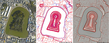
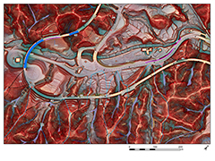
AAS in collaboration with the Archaeological Institute of Kashihara (Nara Prefecture) surveyed tumulus features. A helicopter-based LiDAR system was used to acquire 3D point cloud data that was used to create a digital surface model (DSM) for the tumulus feature. A Red Relief Image Map (RRIM) for the tumulus feature was generated from the DSM. RRIM is a proprietary topographic visualization technology, which was developed by AAS.
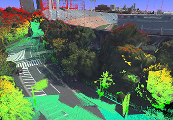
Airborne and Mobile LiDAR Surveying
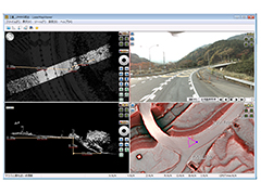
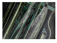
AAS acquired accurate 3D point cloud road surface data using Airborne and Mobile LiDAR systems in order to assess road surface conditions and damages (e.g., cracks, potholes) for MLIT Chubu Regional Development Bureau Mie Office of River and National Highway. Furthermore, AAS proposed a cost-effective road management plan based on Airborne and Mobile LiDAR data. Read more(Japanese version only. ) →
Seamless Airborne LiDAR Bathymetric and Topographic Data
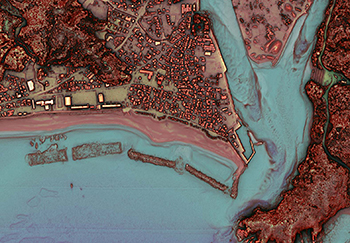
AAS introduced an "Airborne LiDAR Bathymetry (ALB)"system for mapping shallow sea areas using green laser. Bathymetric surveys are affected by sudden weather changes, fishing nets, shallow water and rapid streams. Especially, it is too difficult to conduct surveys on vessels in the extremely shallow sea (1-3 meters of water), where the waves increase in height. ALB, even in such areas, enables safe, efficient, quantitative measurement of water depth with high accuracy.