- HOME
- RECENT ACTIVITIES
- Digital Photogrammetry Training in Zimbabwe (May 2018)
Digital Photogrammetry Training in Zimbabwe (May 2018)
Public-Private Technical Cooperation for Geospatial Capacity Development
After the completion of “The Development of a Geospatial Information Database Project” (hereafter referred to as the “Harare Mapping Project”) that was funded by the Japan International Cooperation Agency (JICA) between 2015 and 2017, the Department of Surveyor General (DSG) requested Asia Air Survey (AAS) Co., Ltd for further technical assistance. In response to DSG’s requests, AAS conducted two weeks Azuka digital photogrammetry training in May 2018 at the DSG Headquarters in Harare, Zimbabwe. Azuka is a proprietary digital photogrammetry that was developed by AAS.
Background
After the completion of the “Harare Mapping Project”, DSG procured three digital photogrammetry workstations (DPW) in order to complete the 1:5,000 scale topographic map production of the remaining parts of Harare. However, DSG lacked the technical capacity to complete the 1:5,000 scale topographic mapping. Therefore, DSG required further technical training from external experts in order to strengthen its digital photogrammetry capacity. In this regard, DSG requested AAS for further digital photogrammetry technical training since the latter was the consultant that implemented the “Harare Mapping Project”. In response, AAS donated three months Azuka license, while DSG paid part of training cost.
Training outline
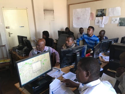
During the training, AAS explained the operational methods of Azuka with demonstration. Furthermore, AAS offered practical hands-on training for: (1) setting-up digitizing and map symbol in Zimbabwe; (2) field check; and (3) digitizing of Harare city.
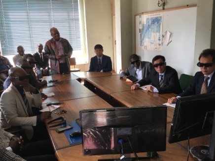
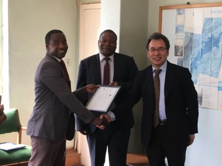
Last but not least, DSG presented about training results and a ceremony to confer the certificate was held during the final day. DSG commented that Azuka was a user-friendly software.
Training results and future plan
The training was finished as scheduled, and DSG appreciated AAS’s cooperation for this training. In the training, a digitizing plan using Azuka was prepared for the future. DSG and AAS reiterated the need for further cooperation not only for the installation of Azuka but also inclusive support related to geospatial data production.
JICA and Japan External Trade Organization (JETRO) visited DSG for the training since they have interest in this public-private technical cooperation. This training was an effort by the Government of Zimbabwe and the support from private company.
After President Mnangagwa assumed office in November 2017, the economic situation is expected to improve. In order to facilitate economic growth, urban infrastructure development is essential. Therefore, accurate and reliable geospatial datasets such as large-scale digital topographic maps are required. DSG is expected to produce the large amount of geospatial datasets. AAS will continue the technical support to DSG for the future of Zimbabwe.
As it is assumed that the tsunami had an impact on the tidal flats and beds of eelgrass at the mouth of the Orikasa River, fixed-point observation of the impact and state of regeneration will be implemented.
 |
 |
 |
|
Lecture sessions |
Presentation by DSG |
Conferring the certificate |