|
|
We would like to express our sincerest condolences for all victims and their families who have suffered from this catastrophic earthquake and tsunami.
Since March 12th 2011, Asia Air Survey has been continuously taking aerial photos of the distressed areas. Gathered information and images are immediately released on this page and are continuously being updated. We hope that our technology and information aid in preventing the secondary disasters.
|
|
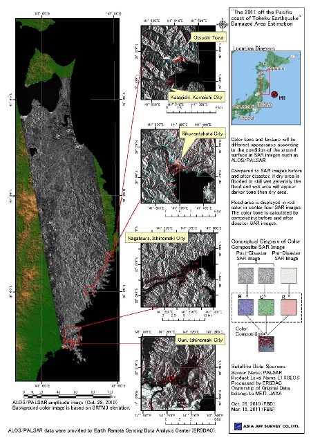
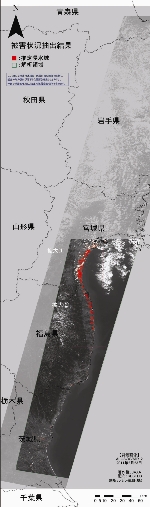
- "The 2011 off the Pacific coast of Tohoku Earthquake" Damaged Area Estimation
Update on April 15, 2011
|
|
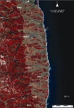
Fig. 8.1
The color tone and texture of SAR images such as ALOS/PALSAR will appear differently due to the flood, destroyed buildings, and changes in vegetation.
The left figures are composite photos of PALSAR images before the disaster (red is assigned) and SAR images after the disaster (blue and green are assigned).
It is estimated that areas in "red" are flooded areas, since SAR images displaying flooded areas appear darker than the same areas before the flood.
High-Resolution Imagery
(size: 3.5MB)
|
- ALOS/PALSAR data were provided by Earth Remote Sensing Data Analysis Center (ERSDAC).
|
|
- Panoramic animation of the periphery of the Sendai Airport taken by LiveView
Update on April 8, 2011
|
March 27, 2011. 360°Panoramic images around the Sendai Airport. You can move and change the viewpoints around the Sendai Airport area.
Click here for a panoramic animation.
Asia Air Survey provides prompt information at a time of natural disasters by taking aerial and surface photos.
|
|
|
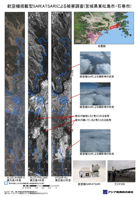
- Damage investigation by SAR(ATSAR) equipped on aircraft
Update on April 7, 2011
|
|
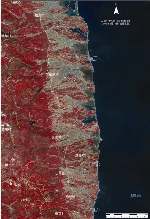
Fig. 7.1
Synthetic Aperture Radar (SAR) can take clear pictures of the ground surface from above the clouds under the bad weather conditions.
Asia Air Survey operates Cessna 208 equipped with a small SAR (manufactured by Alouette Technology Inc) and performed the experimental photography of the aftermath of Ishinomaki City and Higashi Matsuyama City in Miyagi Prefectures, which were damaged significantly by the earthquake and the flood. Flooded and wet areas are normally darker in tone in SAR images. Thus, we are able to make an estimation of the flood damage in the areas utilizing this information. Asia Air Survey provides prompt information on aftermath of natural disasters gathered using a team of mobile aircrafts and all-weather SAR.
High-Resolution Imagery
(size: 7.2MB)
Right-click, and download the target.
Adobe Reader required
|
- ALOS data above is granted from Japan Aerospace Exploration Agency (JAXA) and Remote Sensing Technology Center of JAPAN.
|
|
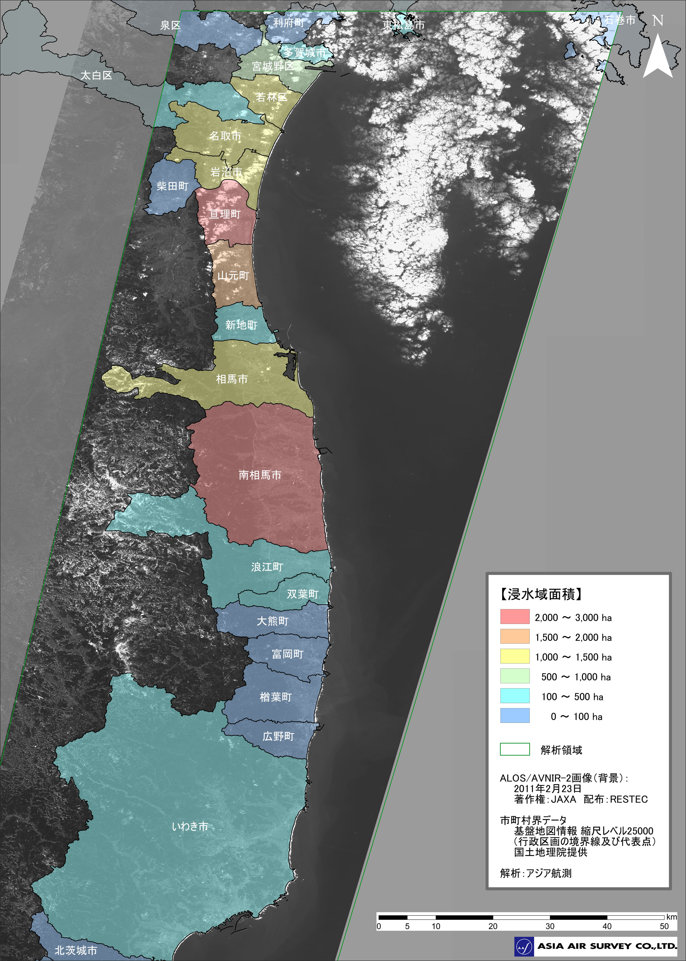
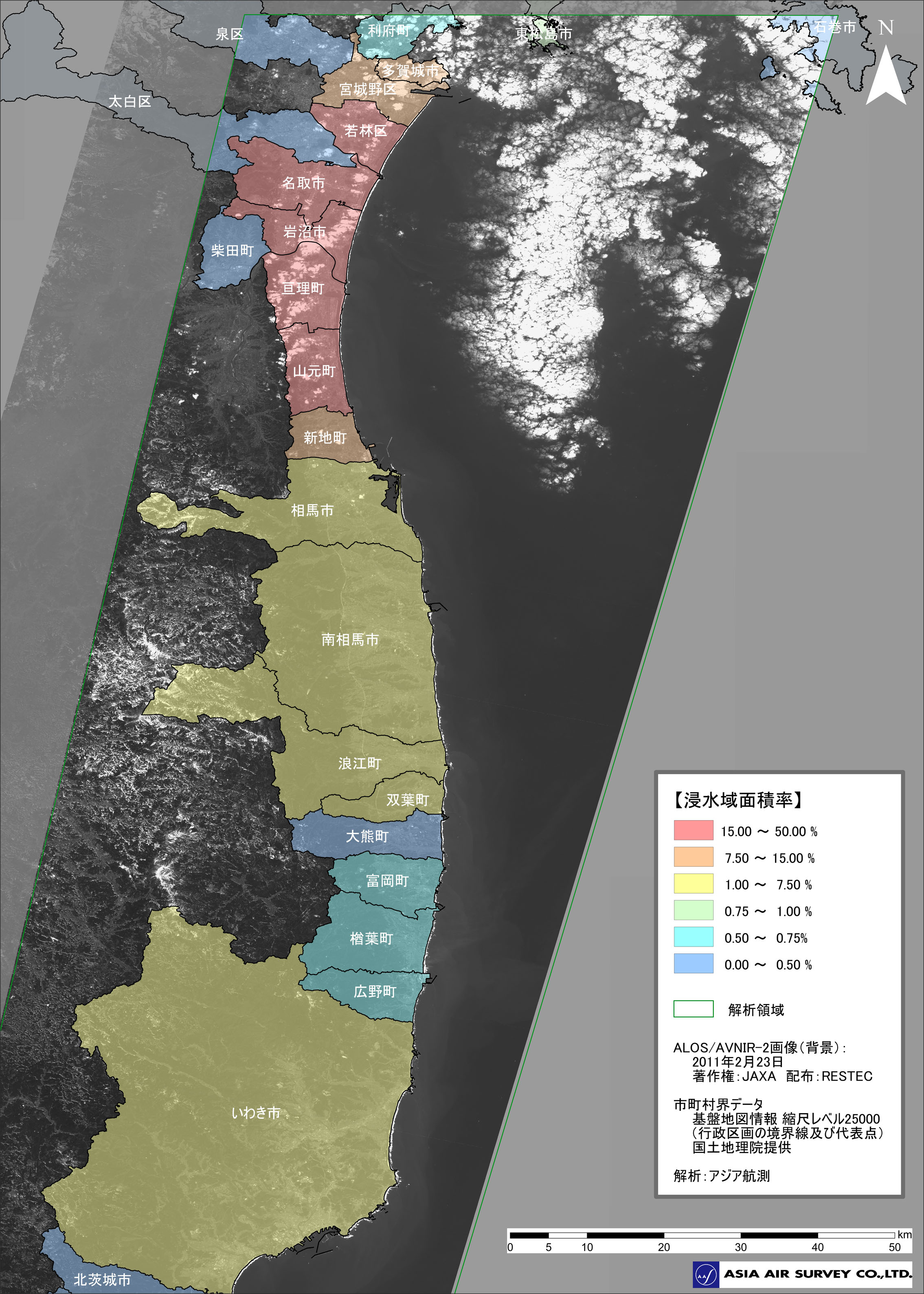
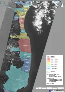
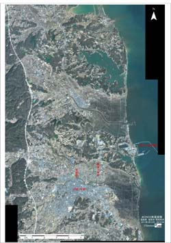
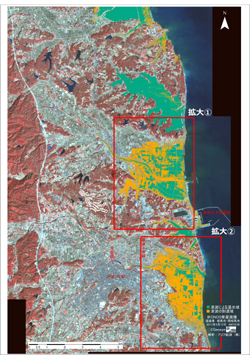
- Total of Damaged areas by municipality and city districts
Update on April 5, 2011
|

|
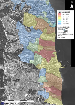
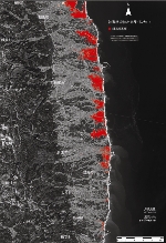
Fig. 6.1
Damaged area according to municipal district town and village
Damaged areas by municipality
Left: Damaged area (ha)
Right: Ratio of damaged area (%)
[ Note ]
Damaged areas are classified into multiple levels by the severity of damages caused by floods. It is done by overlapping the fundamental map information provided by Geospatial Information Authority of Japan and estimated flooded areas inferred from the ALOS satellite images. The areas in red indicate the areas with "severe damages" (The influences upon the areas covered by clouds and outside of the photographing areas are not considered).
|

|
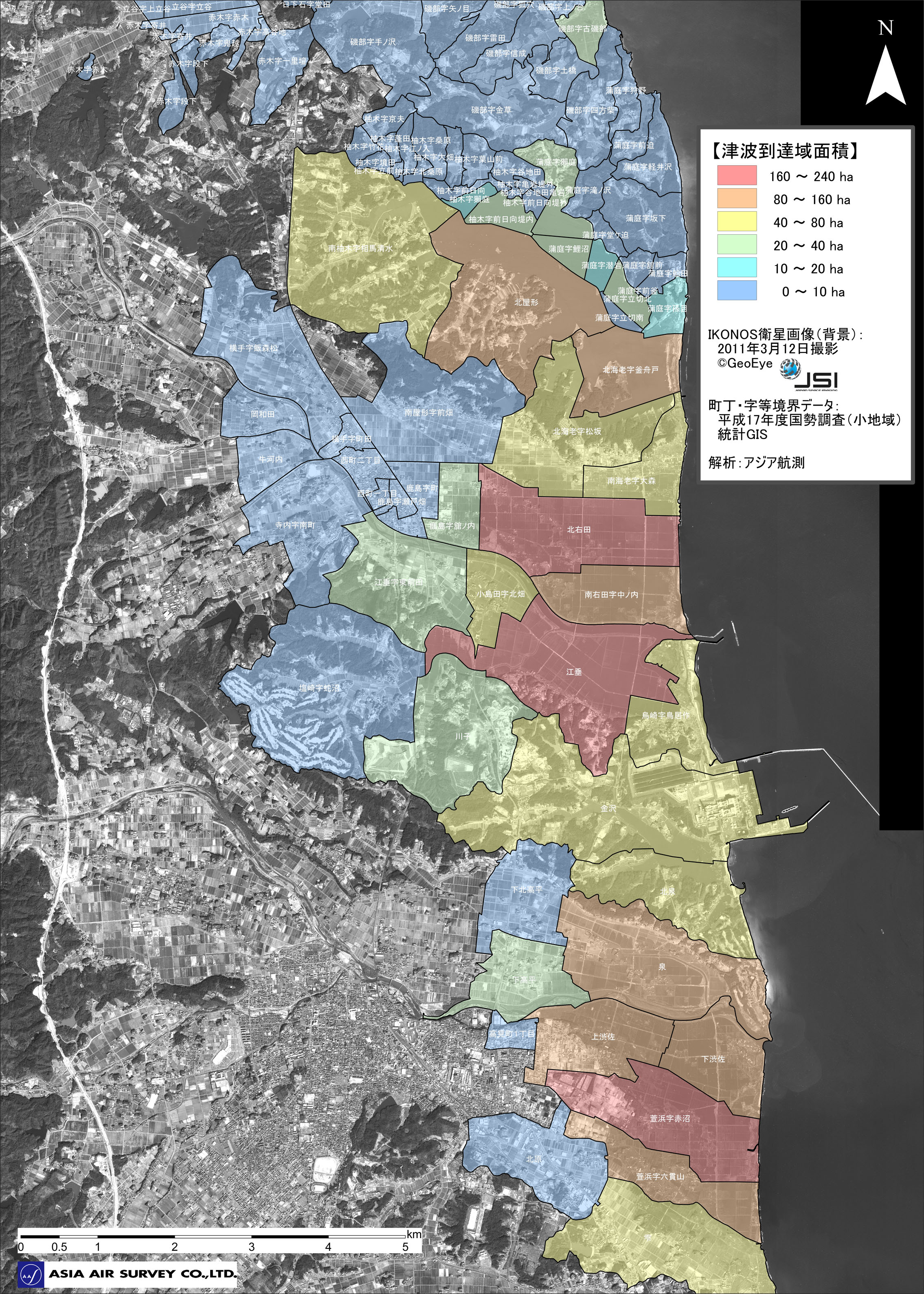
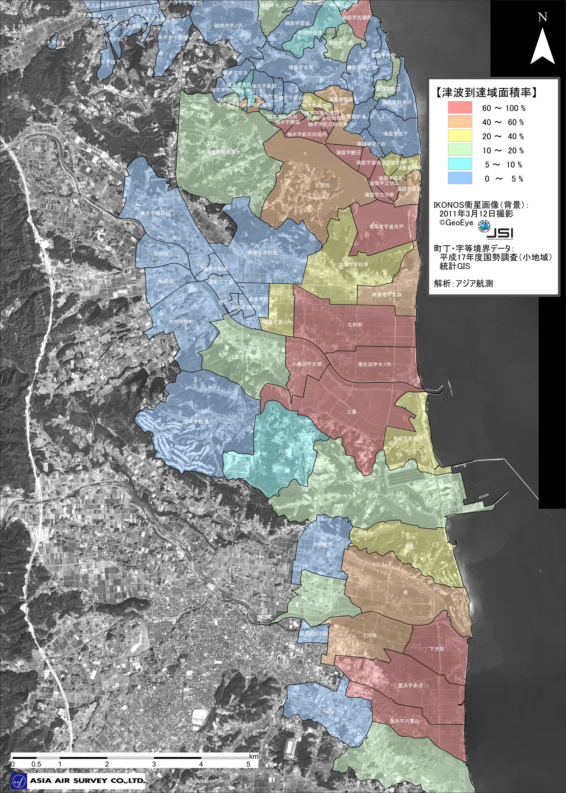
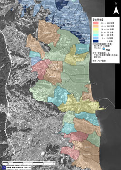
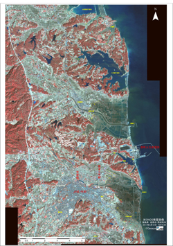
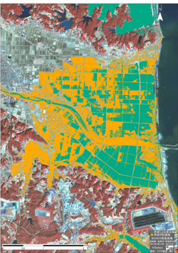
Fig. 6.2
Tsunami-hit areas by city districts (Soma City and Minami Soma City).
Left: Damaged area (ha)
Right: Ratio of damaged area (%)
[ Note ]
Damaged areas are classified into multiple levels by the damage severity caused by floods. It is done by overlapping the regional data obtained through the 2005 National Population Census and estimated flood reached regions inferred from the IKONOS satellite images. The areas in red indicate the areas with "severe damages" (The influences upon the areas outside of the photographing areas are not considered).
|
|
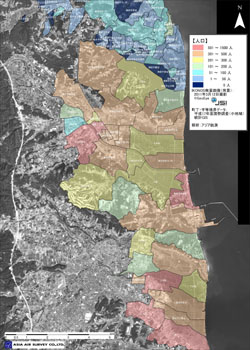
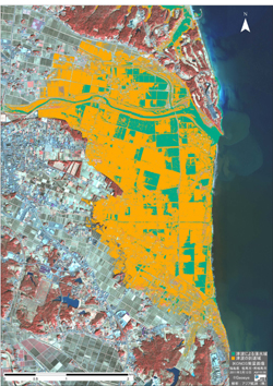
Fig. 6.3 Reference
The number of households/the population by city districts.
(Soma City and Minami Soma City)
Left: The population
Right: Number of households
[ Note ]
Tsunami-hit areas are classified into multiple levels by the population and the number of households of the districts, where the floods reached.
|
- ALOS data above is granted from Japan Aerospace Exploration Agency (JAXA) and Remote Sensing Technology Center of JAPAN.
- The copyright of above images are owned by GeoEye/Japan space imaging company. Reprinting is prohibited.
- The resultant damage situation released on this page is based solely on the information from the satellites images, and may not coincide with the current state.
|
|
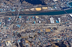
- Estimating the number of buildings in Minami Soma City area
Update on March 29, 2011
|
|
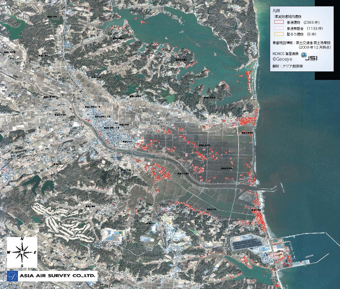
We estimated the number of buildings in regions where Tsunami reached in Minami Soma City inferred from IKONOS satellite images and fundamental map information published by Geospatial Information Authority of Japan.
|
|
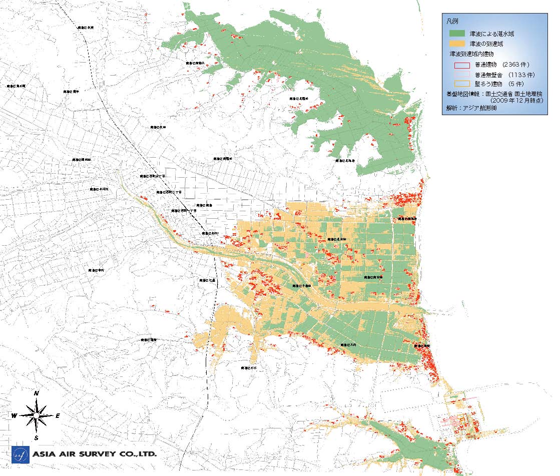
Fig. 5.1
Result of analysis by using vector data
We extracted the buildings data within the Tsunami reached regions by overlapping the analysis results and fundamental map information (of Minami Soma City) published by Geospatial Information Authority of Japan. We used the particular fundamental map information published back in Dec 25, 2009; data prior the disaster.
The following summarizes the findings.
- 2363 Ordinary Buildings
(Ordinary Buildings are defined as buildings three stories or shorter, or wooden buildings three stories or higher.)
- 1133 Ordinary Wall-less Buildings
(Ordinary Wall-less Buildings are defined as constructions similar to wall-less buildings (ex, barns), greenhouses, or buildings within factories and all are three stories or shorter.)
- 5 Reinforced Concrete Structure Buildings
with 3 stories or higher
High-Resolution Imagery
(size:10.1MB)
Due to the huge size of the image, please right-click on the link above and save the image before opening it. (Layer display can be turned on/off using the layer function in ADOBE Reader. Also, analysis function controls the display of the latitude and longitude information.)
|
|
Fig. 5.2
Result of Analysis using Raster Data
We overlapped the buildings data within the Tsunami reached regions and the IKONOS raster data (taken on March 12, 2011). The image shows the locations of buildings (as of December 25, 2009) and rubble, wracks and debris around the city.
High-Resolution Imagery
(size:30.9MB)
Due to the huge size of the image, please right-click on the link above and save the image before opening it. (Layer display can be turned on/off using the layer function in ADOBE Reader. Also, analysis function controls the display of the latitude and longitude information.)
|
|
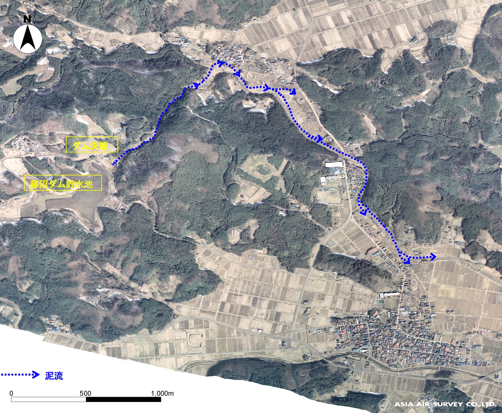
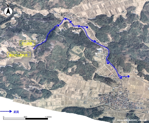
- Dam Failure in Sukagawa City , Fukushima Prefecture
Update March 29, 2011
|
|
Fig. 4.1
Shooting March 14, 2011
The Fujinuma dam (height: 17.5m) collapsed immediately after the earthquake on March 11.
Floods and mudflow triggered by dam failure traveled over 3 km downstream to the Naganuma district. The DMC (Digital Mapping Camera) image to the left was taken on March 14, 2011. Its resolution was reduced to approximately 1m, and the vast region was orthorectified.
|
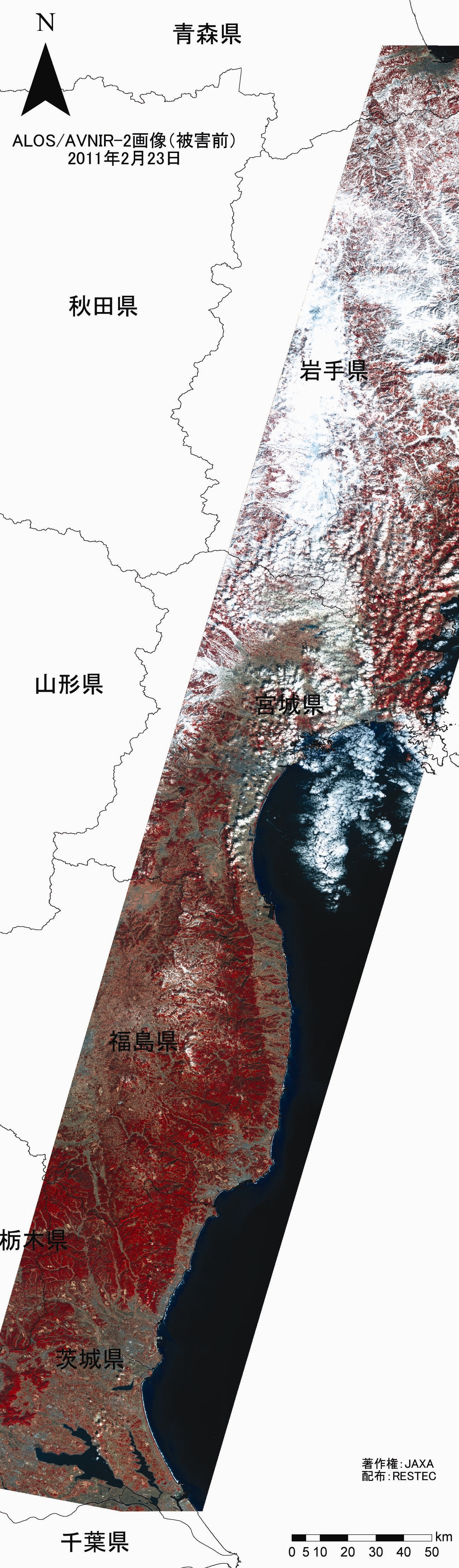
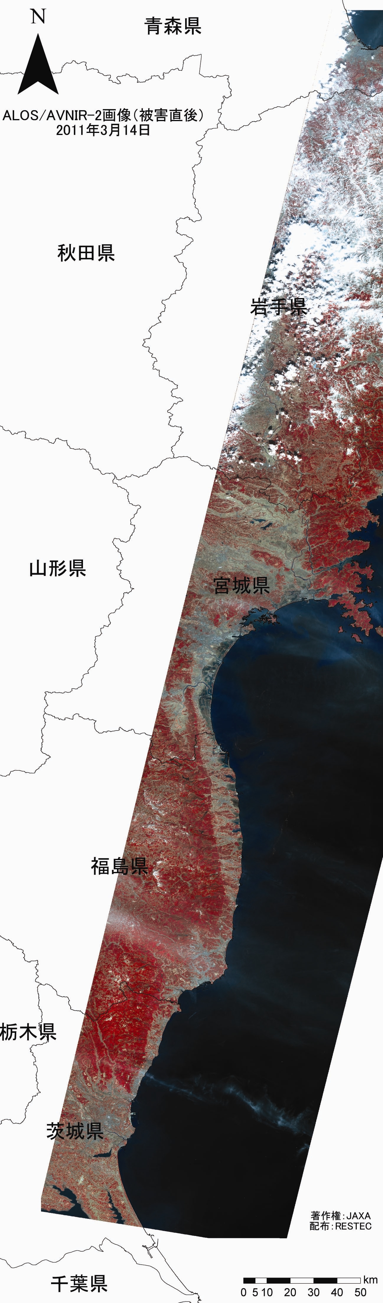
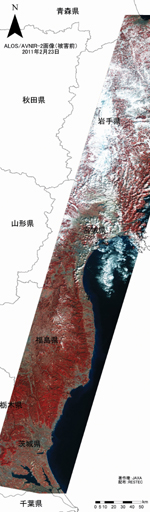
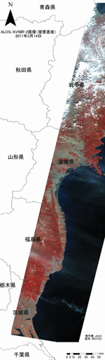
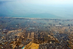
- MIYAGI & FUKUSHIMA Coast -
Damage analysis by multispectral sensor (AVNIR-2) equipped on the Advanced Land Observing Satellite "DAICHI" (ALOS)
Updated 18 March, 2011
|
|
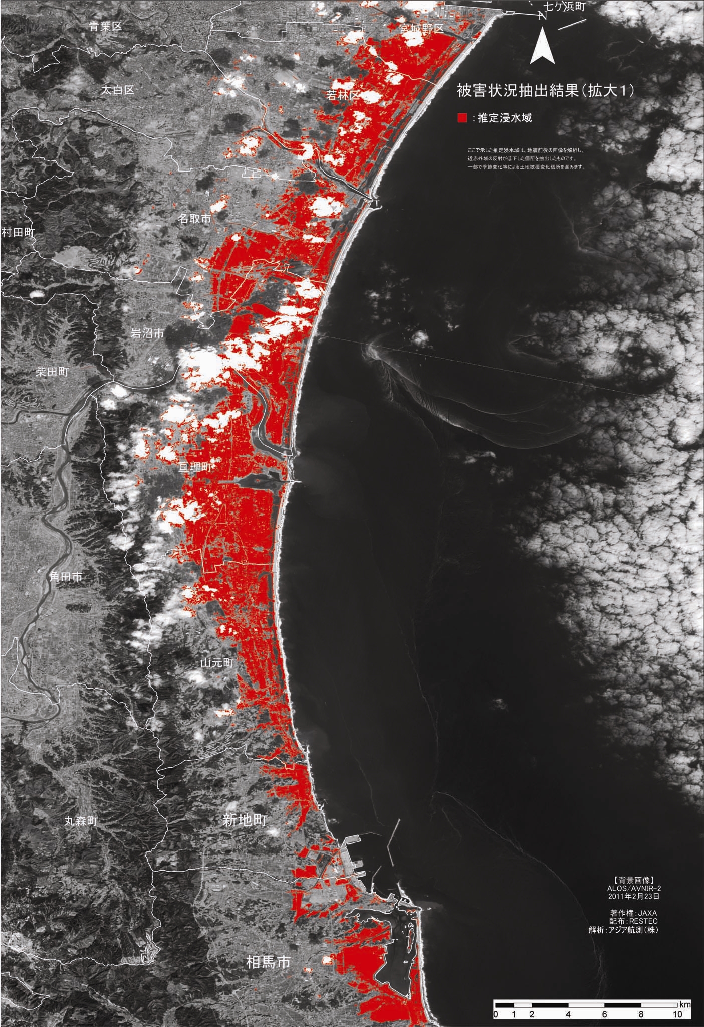
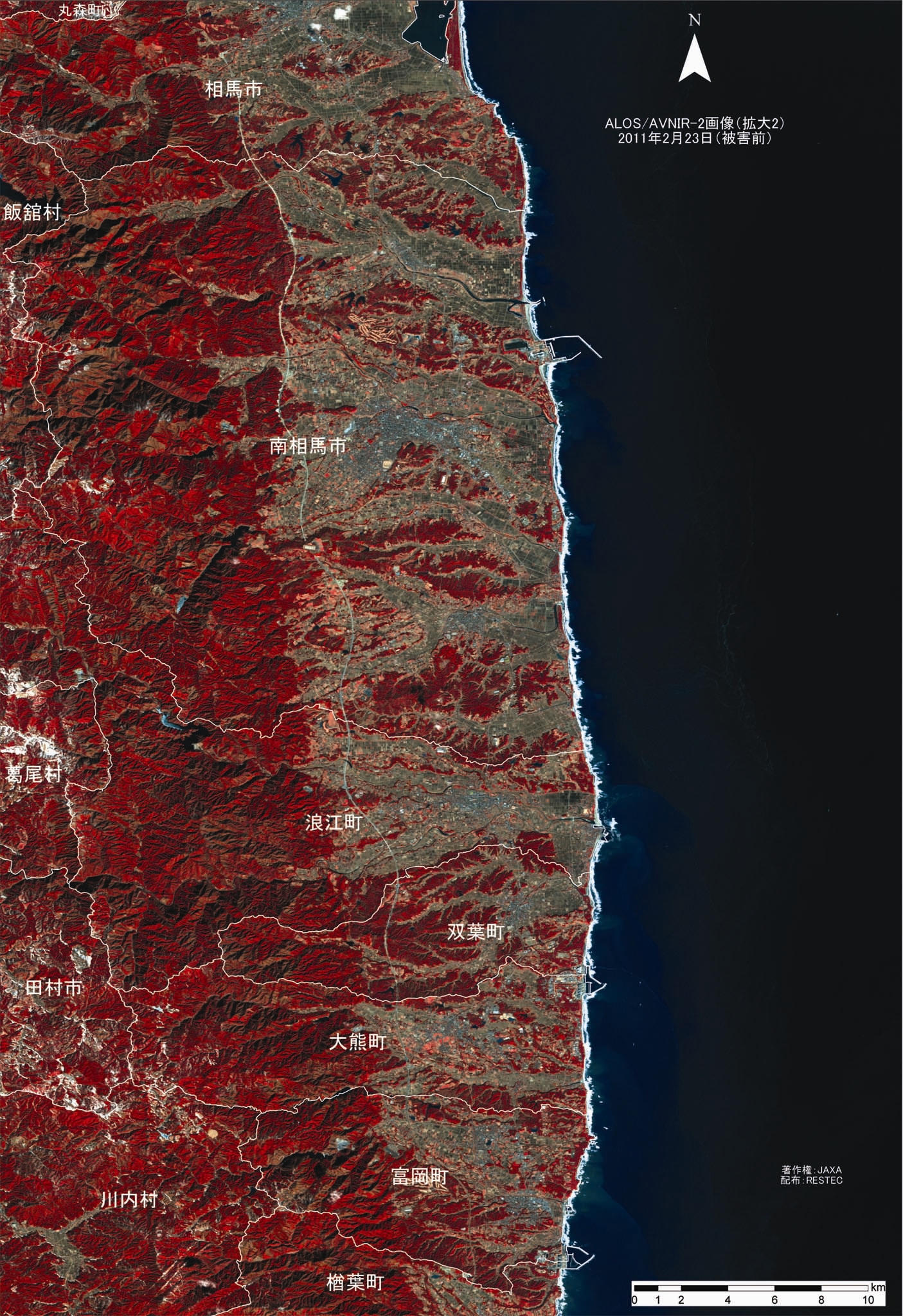
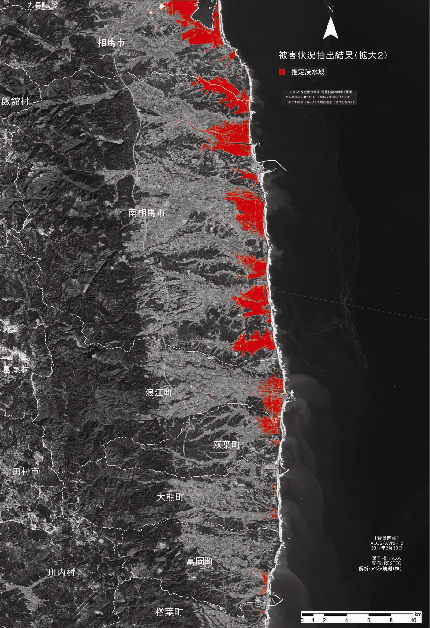
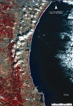
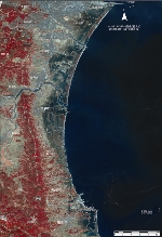
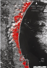
Fig. 3.1 Overview the coast
Left: Before the disaster (infrared color)
Shooting date: 23 February, 2011
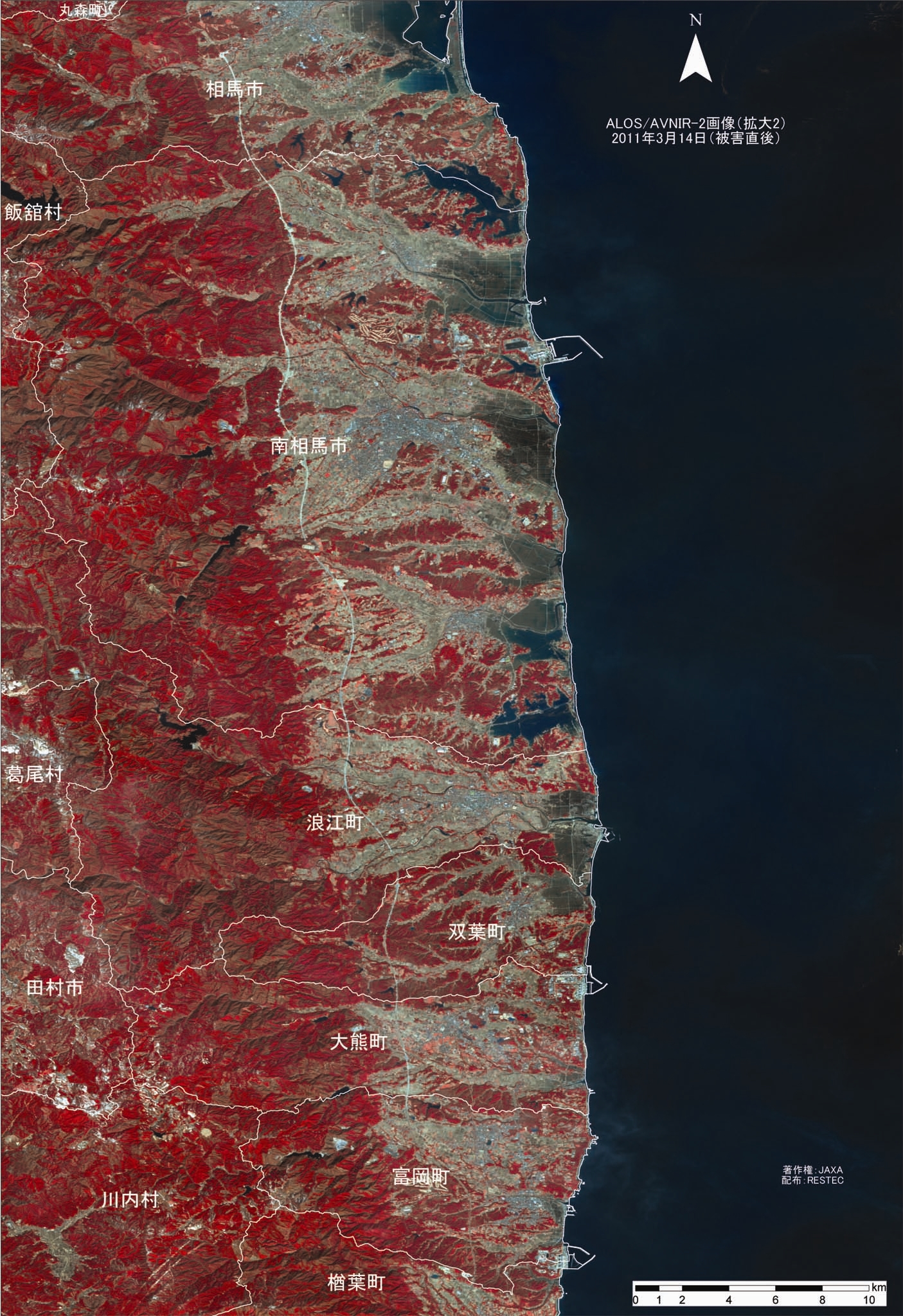
Center: Immediately after the disaster (infrared color)
Shooting date: 14 March, 2011
Right: Extraction result of damages
[legend]
Red: Estimated Flooded area.
*Overlapped before disaster image. The background is the image before the disaster.
*Excluded cloud areas from the analysis range.
[ Explanation ]
Near-infrared electromagnetic waves are strongly absorbed by the water surface. In order to identify the flooded area, we applied the above property and compared the images before and after the earthquake to look for the area where the decrease in reflection in a near-infrared band occurred. Then we extracted such area as the estimated flooded area. The image shows that most of the plains along the coast from Miyagi Prefecture to Fukushima Prefecture particularly suffered massive damages.
|
|
Fig. 3.2 Close-up Images (1)
Left: Before the disaster (infrared color)
Center: Immediately after the disaster (infrared color)
Right: Extraction result of damages.
[Location]
The coast of southern Miyagi Prefecture.
|
|
Fig. 3.3 Close-up Images (2)
Left: Before the disaster (infrared color)
Center: Immediately after the disaster (infrared color)
Right: Extraction result of damages
[Location]
Northern part of Fukushima Prefecture.
|
- The resultant damage situation released on this page is based solely on the information from the satellites images (, and may not coincide with the current state.)
- Above ALOS data is granted from JAXA and Remote Sensing Technology Center of JAPAN.
- The copyright of the following images are owned by JAXA and Remote Sensing Technology Center of JAPAN. Reprinting is prohibited.
-Images (infrared color); Fig. 3.1 left & center, Fig. 3.2 left & center, and Fig. 3.3 left & center.
|
|
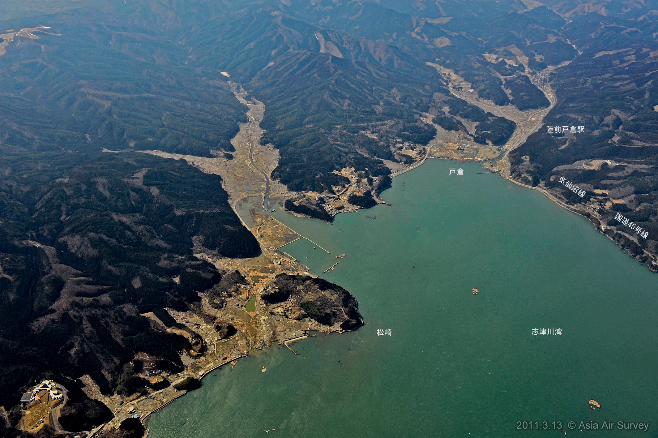
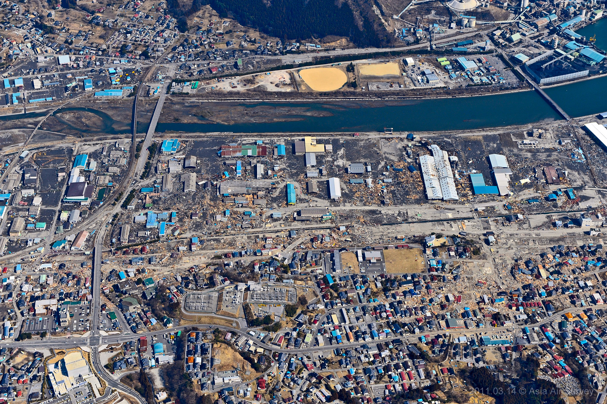
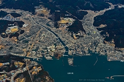
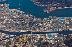
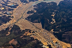
Taken on 14 March 2011 - The Sanriku coast diagonal aerial photos.
|

|
Photograph# 4.1(Shooting number _GYO2120)11:25
Togura , Minami-sanriku cho
|

|
Photograph# 4.2(Shooting number _GYO2124)11:27
Shizugawa , Minami-sanriku cho
|
|
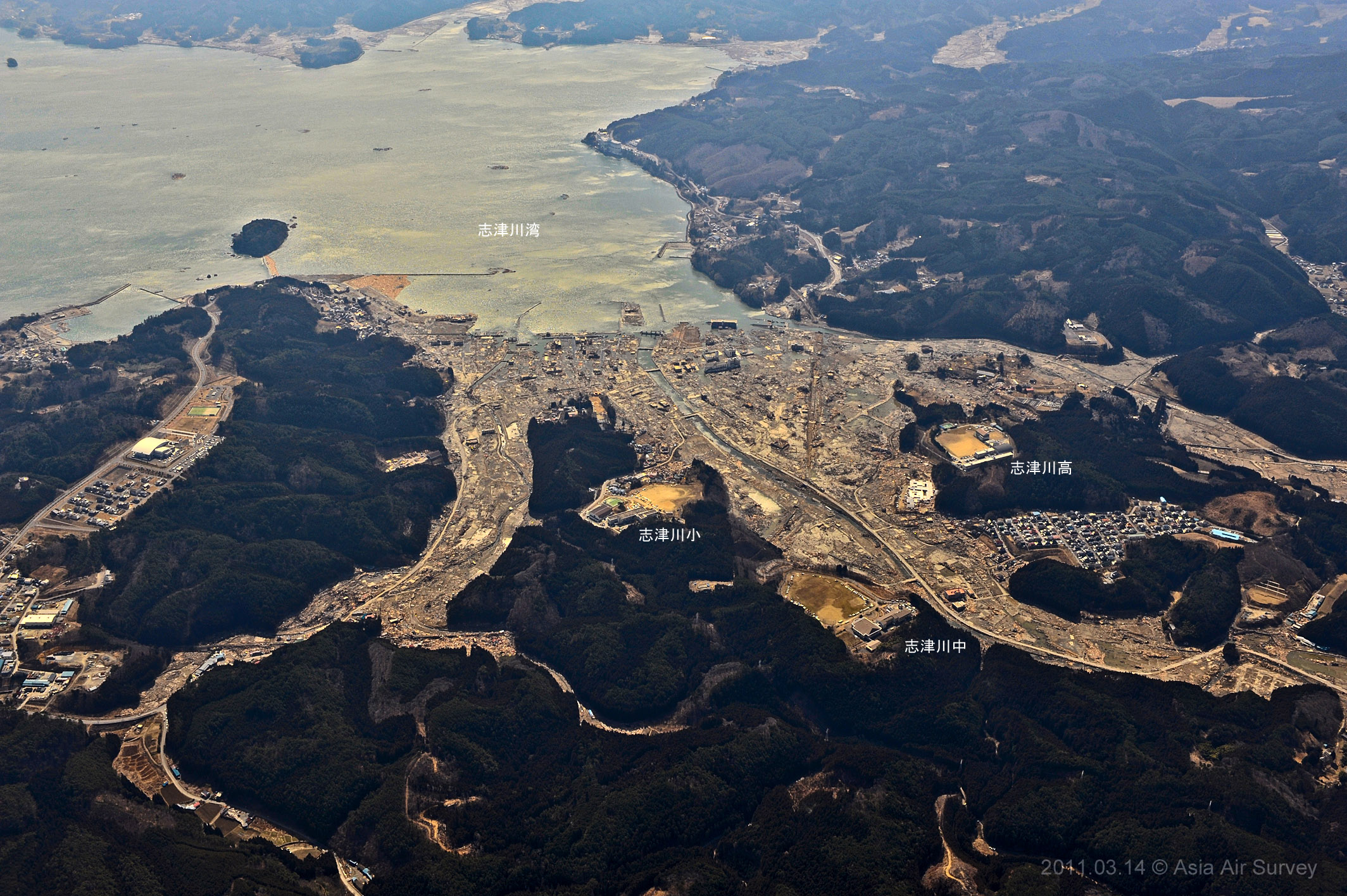
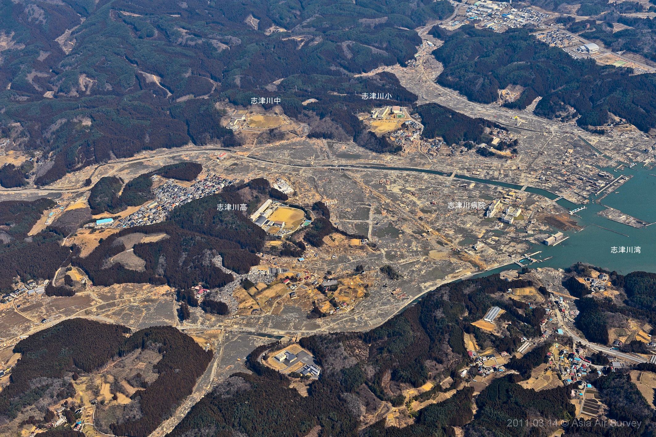
Photograph# 4.3(Shooting number _GYO2127)11:30
Shizugawa high school , Minami-sanriku cho
|
|
Photograph# 4.4(Shooting number _GYO2129)11:30
Shizugawa , Minami-sanriku cho
|
|
Photograph# 4.5(Shooting number _GYO2132)11:35
Iwaisaki , Kesen-numa-city
|
|
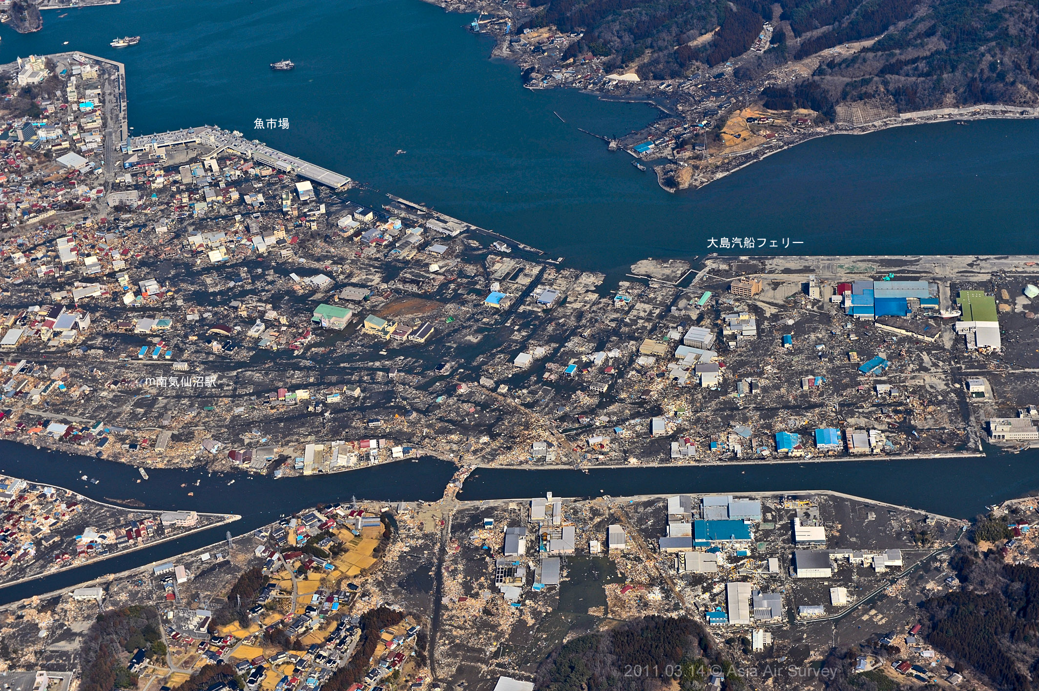
Photograph# 4.6(Shooting number _GYO2143)11:41
Minami-kesen-numa station , Kesen-numa-city
|
|
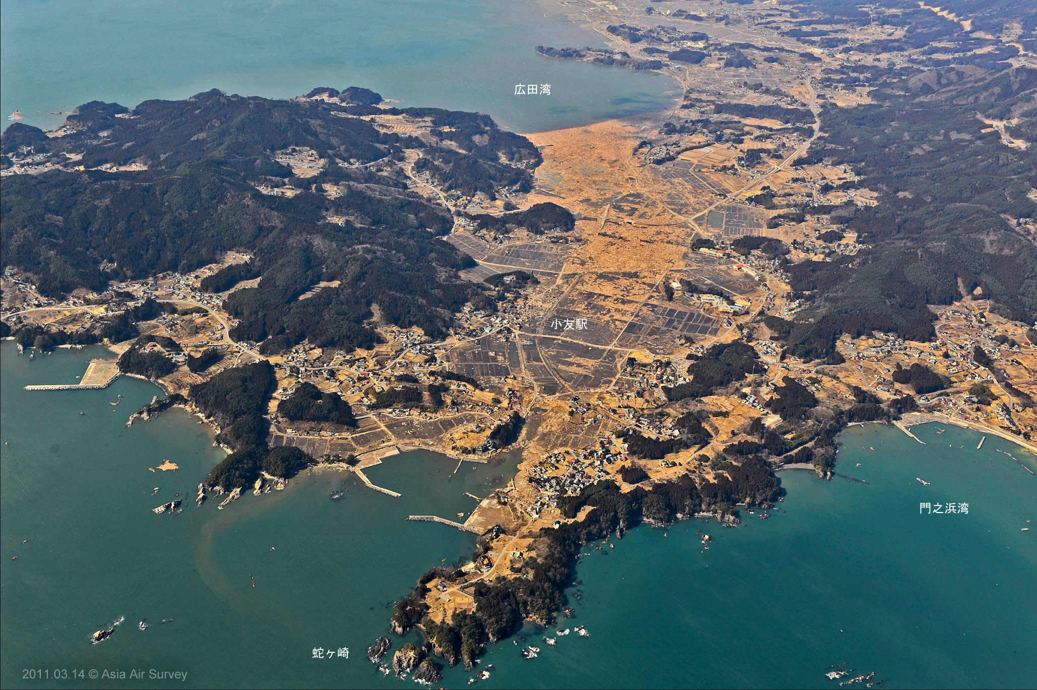
Photograph# 4.7(Shooting number _GYO2150)11:45
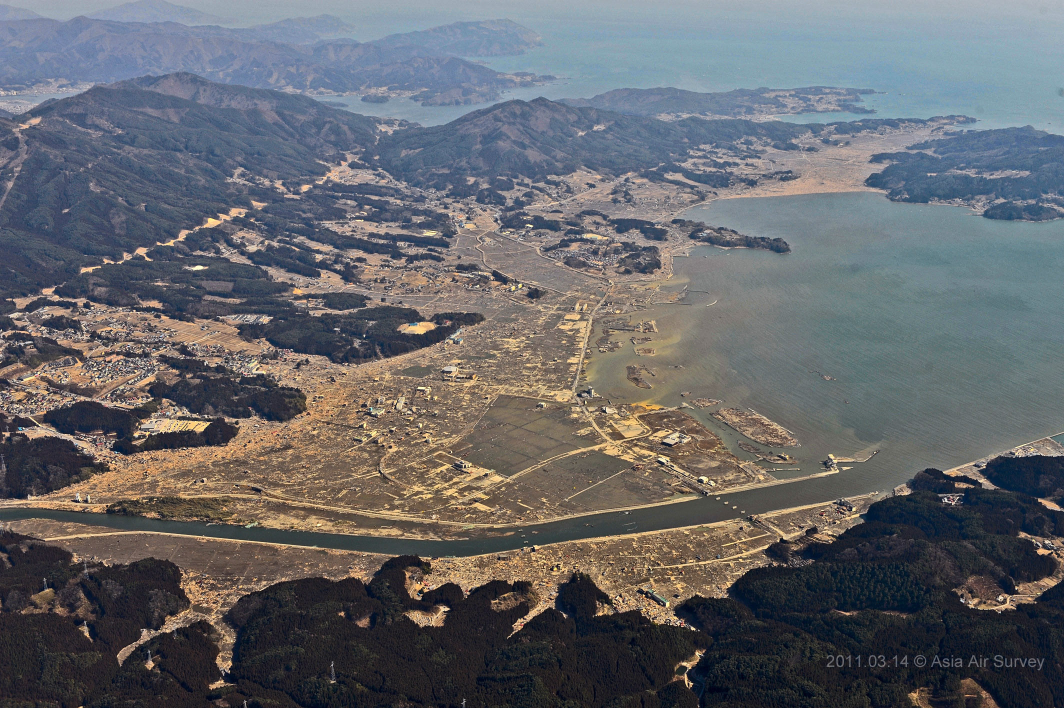
Otomo , Rikuzen-takata-city
|
|
Photograph# 4.8(Shooting number _GYO2157)11:52
Shimoyasaku , Rikuzen-takata-city
|

|
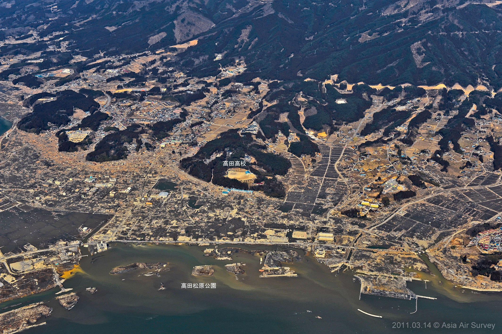
Photograph# 4.9(Shooting number _GYO2159)11:53
Rikuzen-takata-city
|
|
Photograph# 4.10(Shooting number _GYO2162)11:54
Takadamatsubara , Rikuzen-takata-city
|
|
Photograph# 4.11(Shooting number _GYO2165)11:55
Otomo , Rikuzen-takata-city
|
|
Photograph# 4.12(Shooting number _GYO2166)11:55
Otomo , Rikuzen-takata-city
|
|
Photograph# 4.13(Shooting number _GYO2174)12:02
Sunamori , Ofunato-city
|
|
Photograph# 4.14(Shooting number _GYO2180)12:03
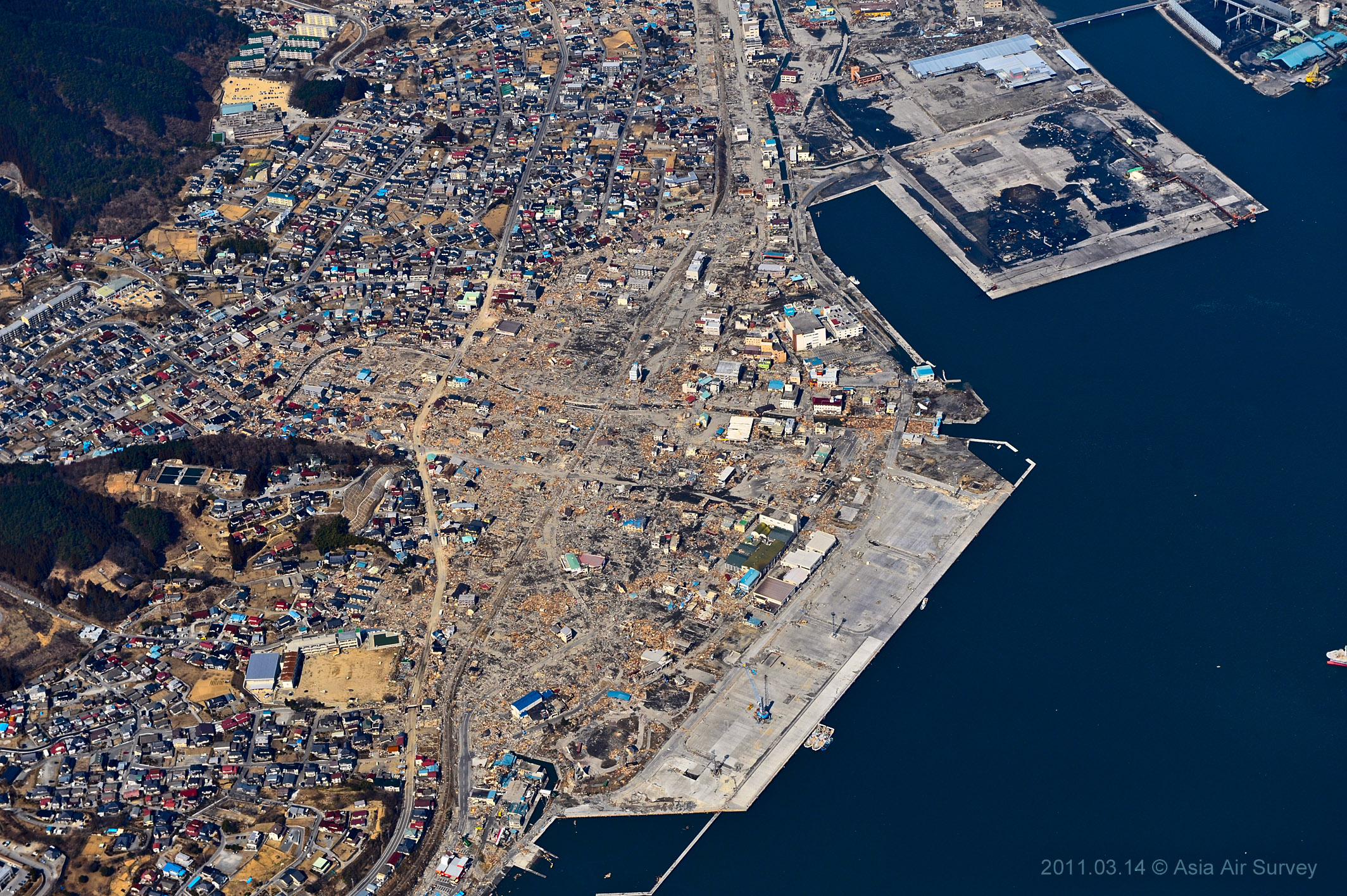
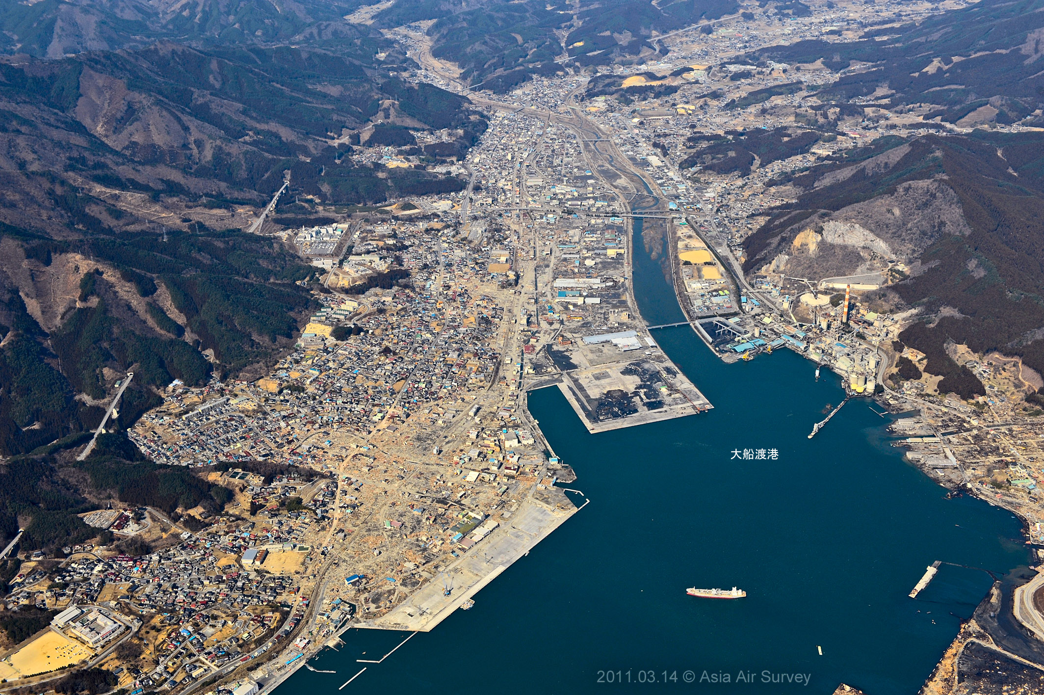
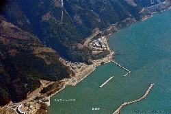
Ofunato port , Ofunato-city
|

|
Photograph# 4.15(Shooting number _GYO2181)12:03
Ofunato-city
|
|
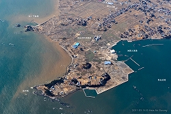
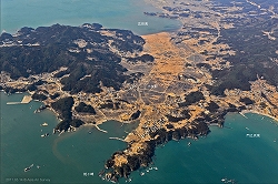
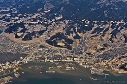
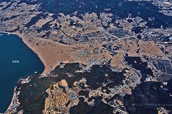
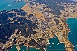
13 March 2011 - The Sanriku coast diagonal aerial photos.
|
|
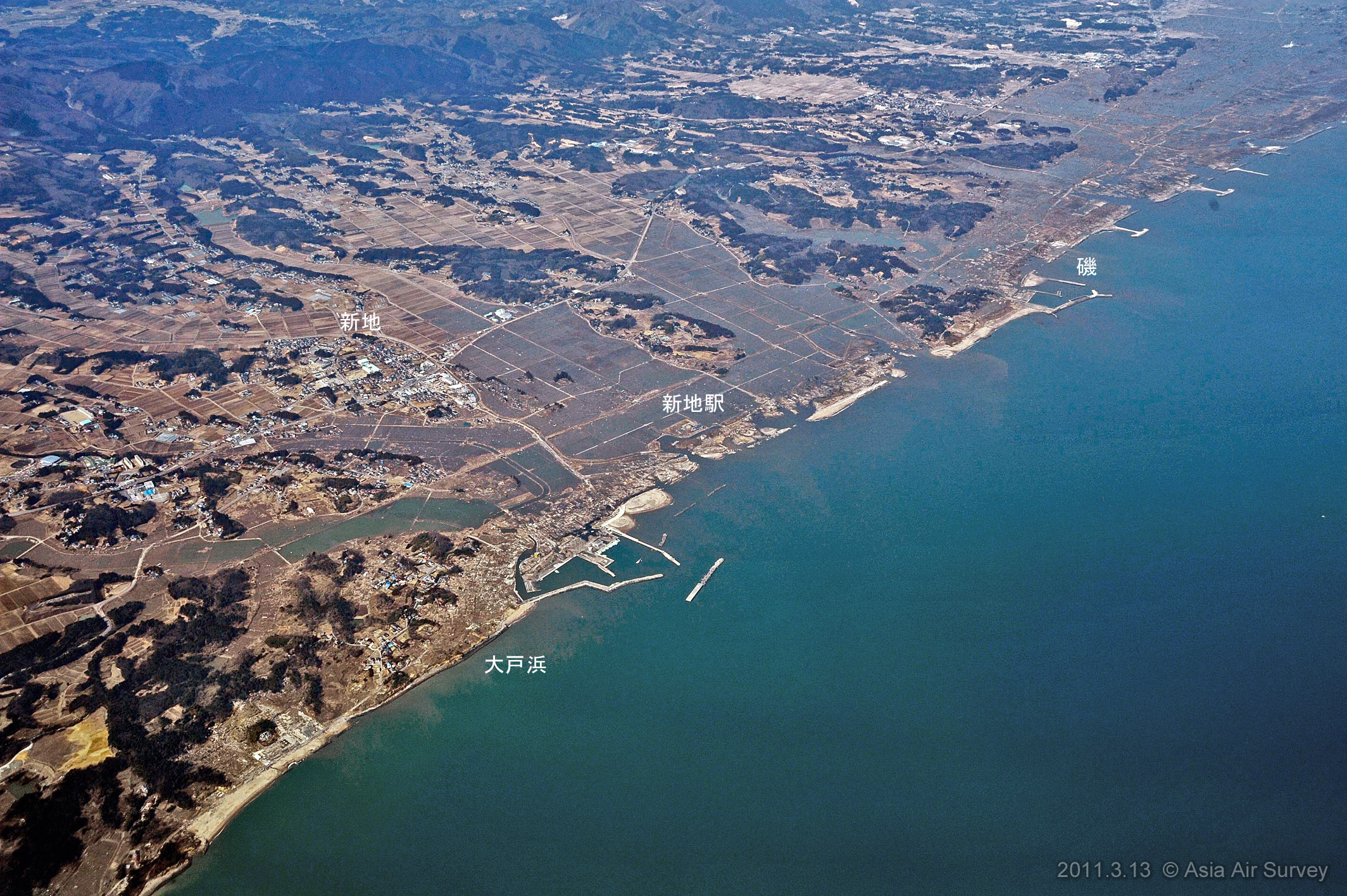
Photograph# 3.1(Shooting number _GYO1692)10:51
Shinchi station
|
|
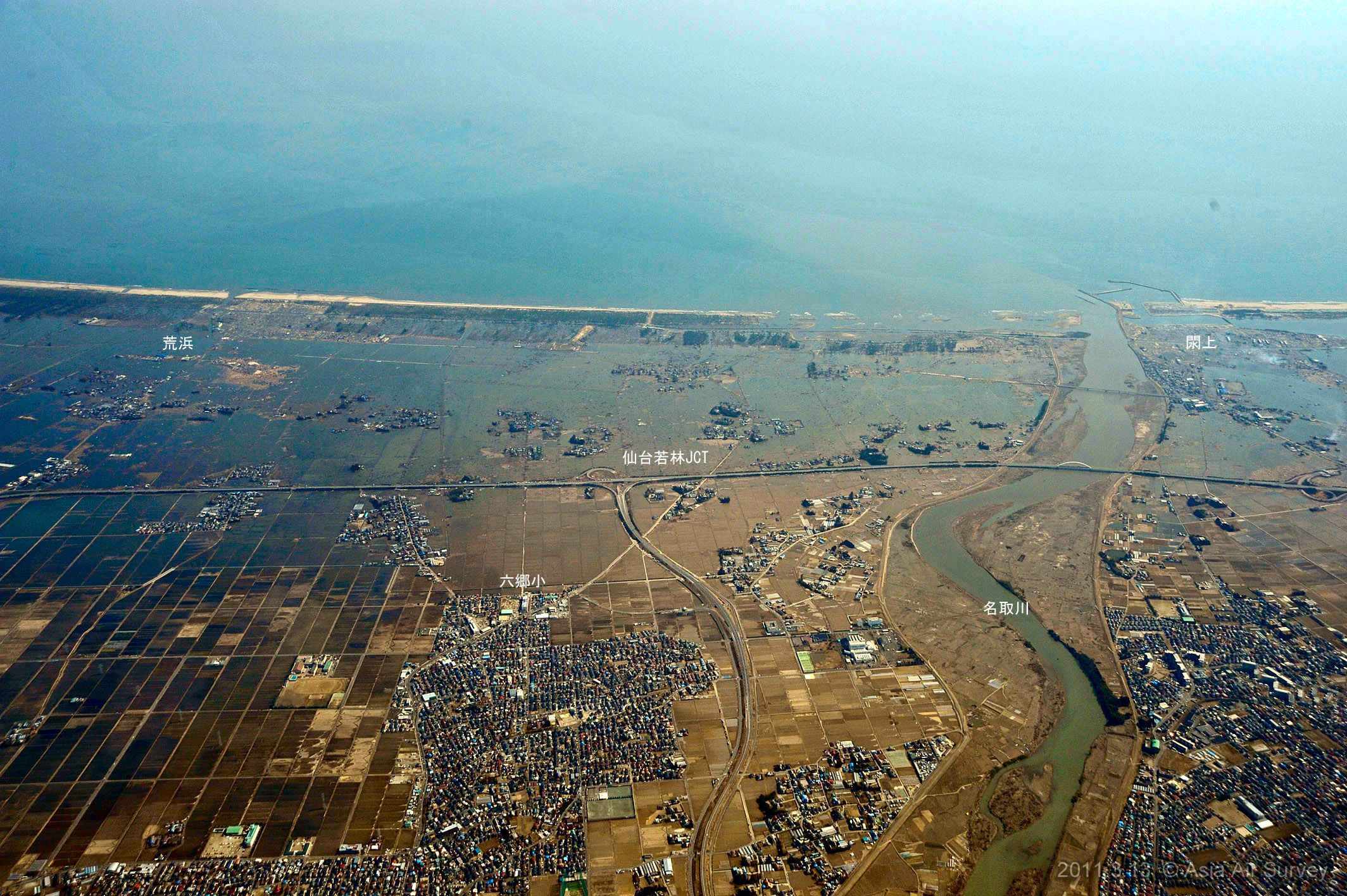
Photograph# 3.2(Shooting number _GYO1702)11:51
Wakabayashi Ward , Sendai-city
|
|
Photograph# 3.3(Shooting number _GYO1704)11:52
Wakabayashi junction
|
|
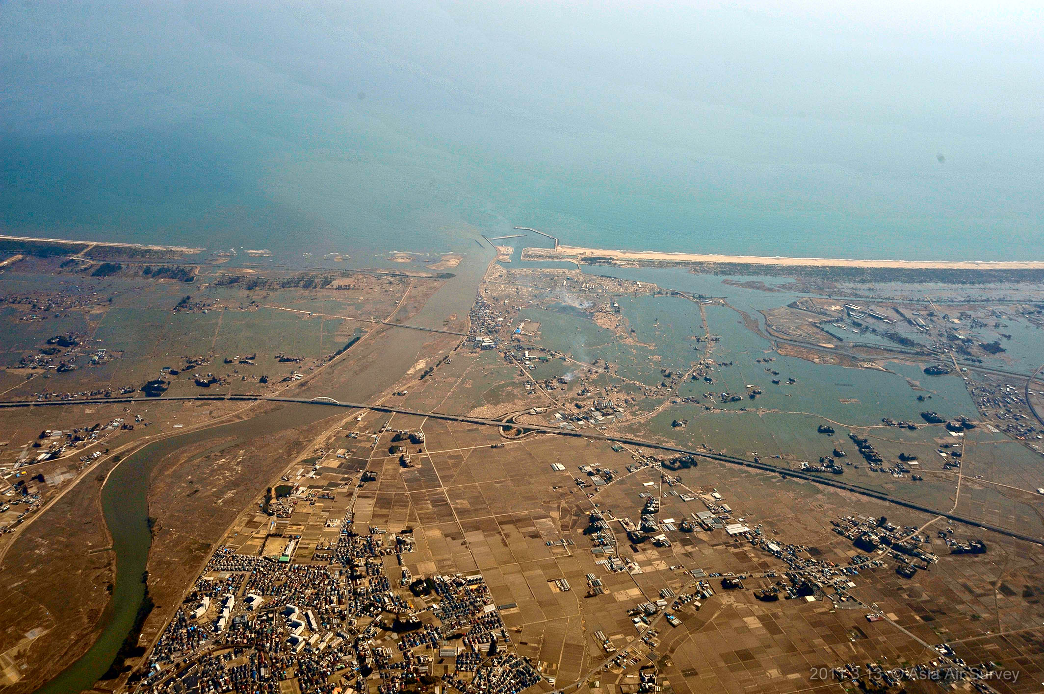
Photograph# 3.4(Shooting number _GYO1705)11:52
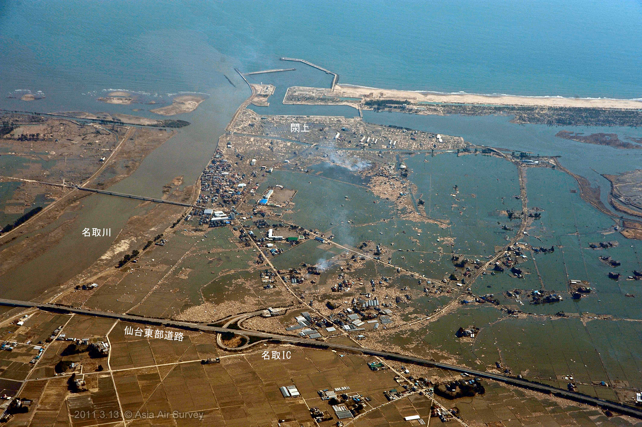
yuriage , Natori-city
|
|
Photograph# 3.5(Shooting number _GYO1706)11:52
yuriage , Natori-city
|
|
Photograph# 3.6(Shooting number _GYO1707)11:53
Mitazono station , Natori-city
|

|
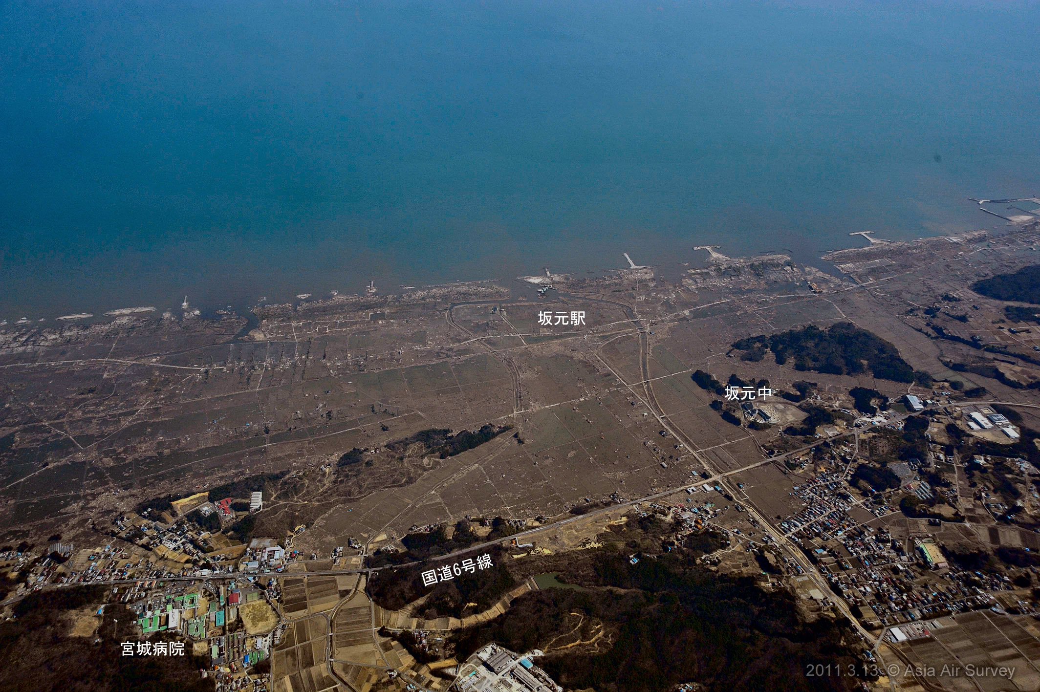
Photograph# 3.7(Shooting number _GYO1719)11:58
Sakamoto station
|

|
Photograph# 3.8(Shooting number _GYO1721)12:36
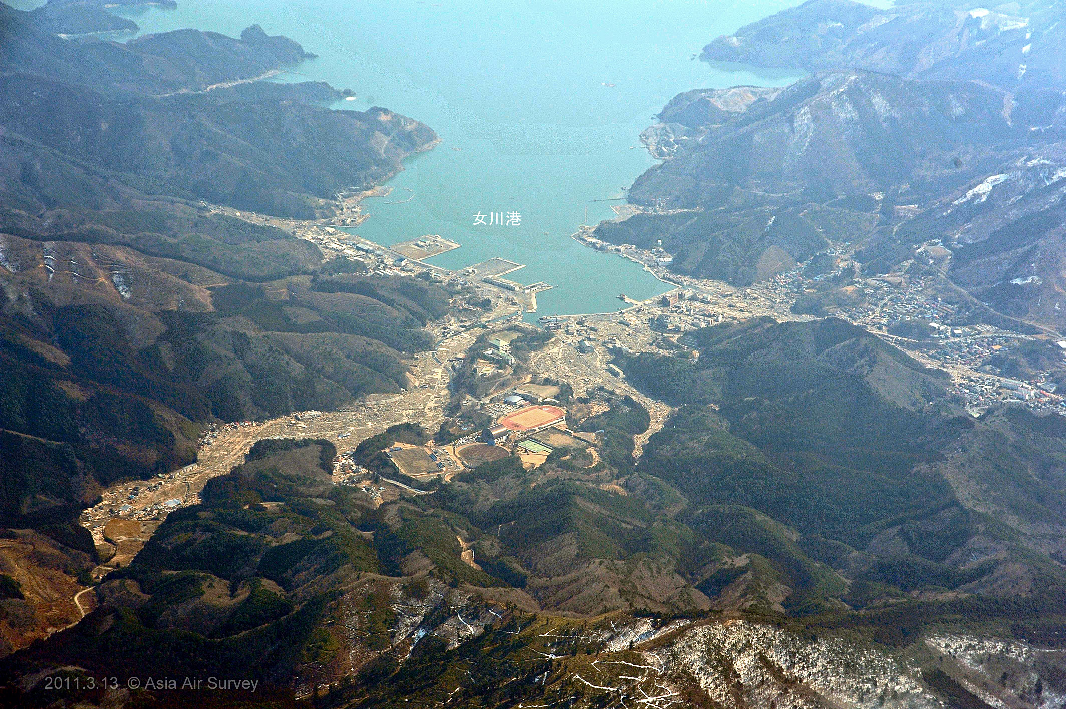
Onagawa-cho
|
|
Photograph# 3.9(Shooting number _GYO1725)12:50
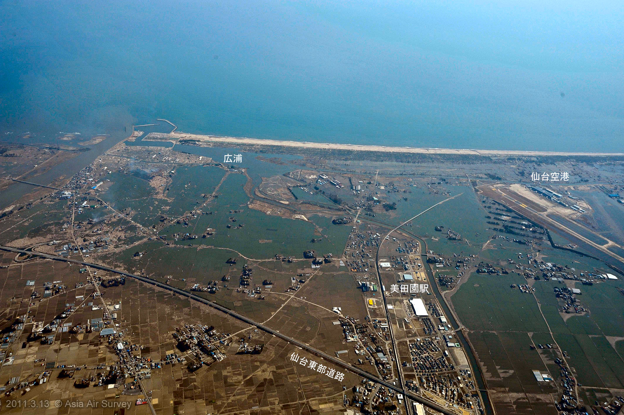
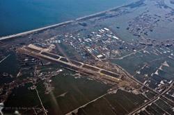
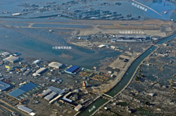
Sendai airport
|

|
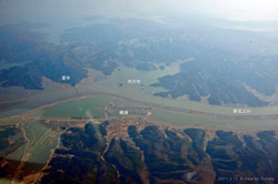
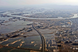
Photograph# 3.10(Shooting number _GYO1728)12:59
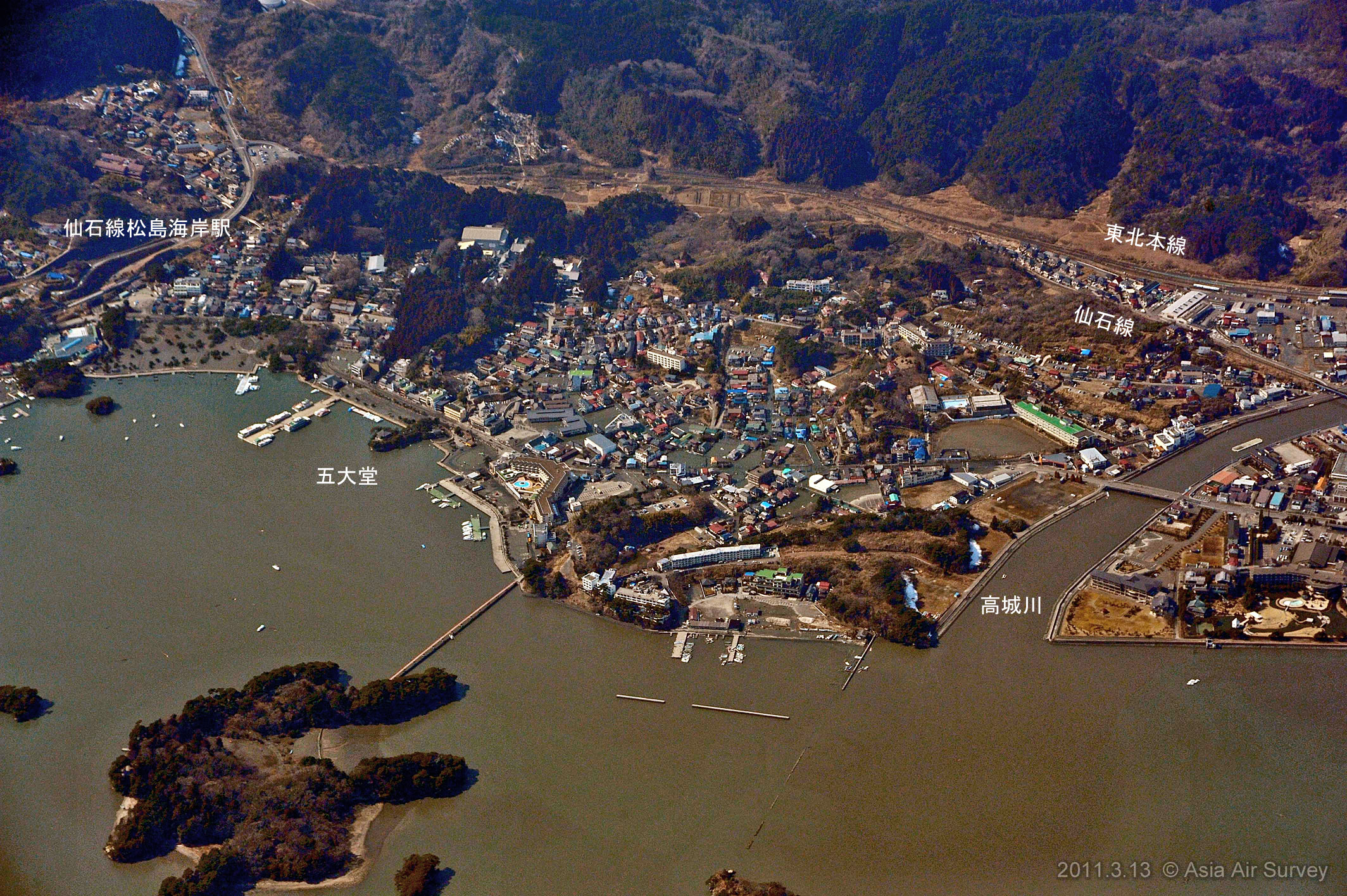
Matsushima coast
|
|
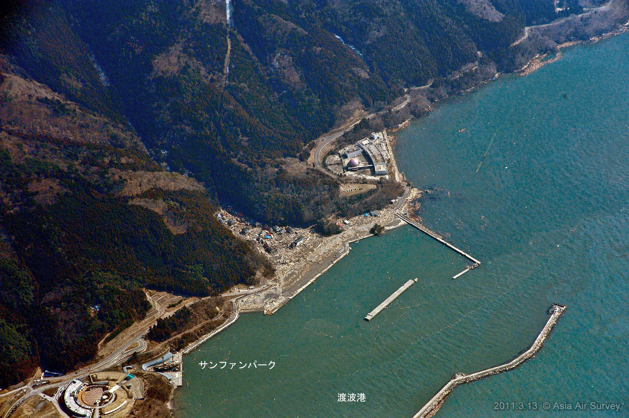
Photograph# 3.11(Shooting number _GYO1729)13:08
Ishinomaki Sun-Juan park
|
|
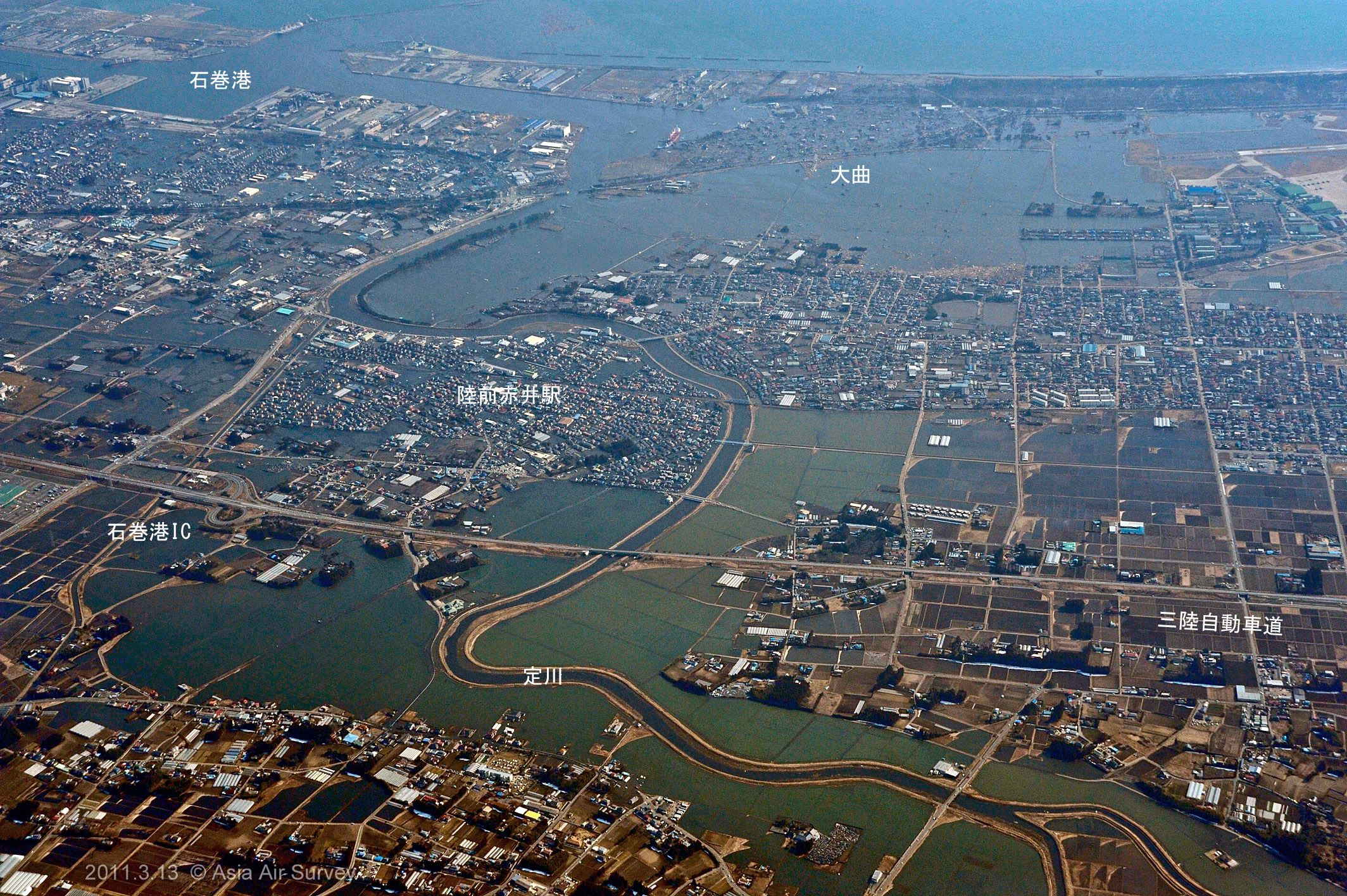
Photograph# 3.12(Shooting number _GYO1730)13:37
Hashiura , Kitakami , Ishinomaki-city
|
|
Photograph# 3.13(Shooting number _GYO1742)13:42
Rikuzen-akai station , Higashi-matsushima-city
|
|
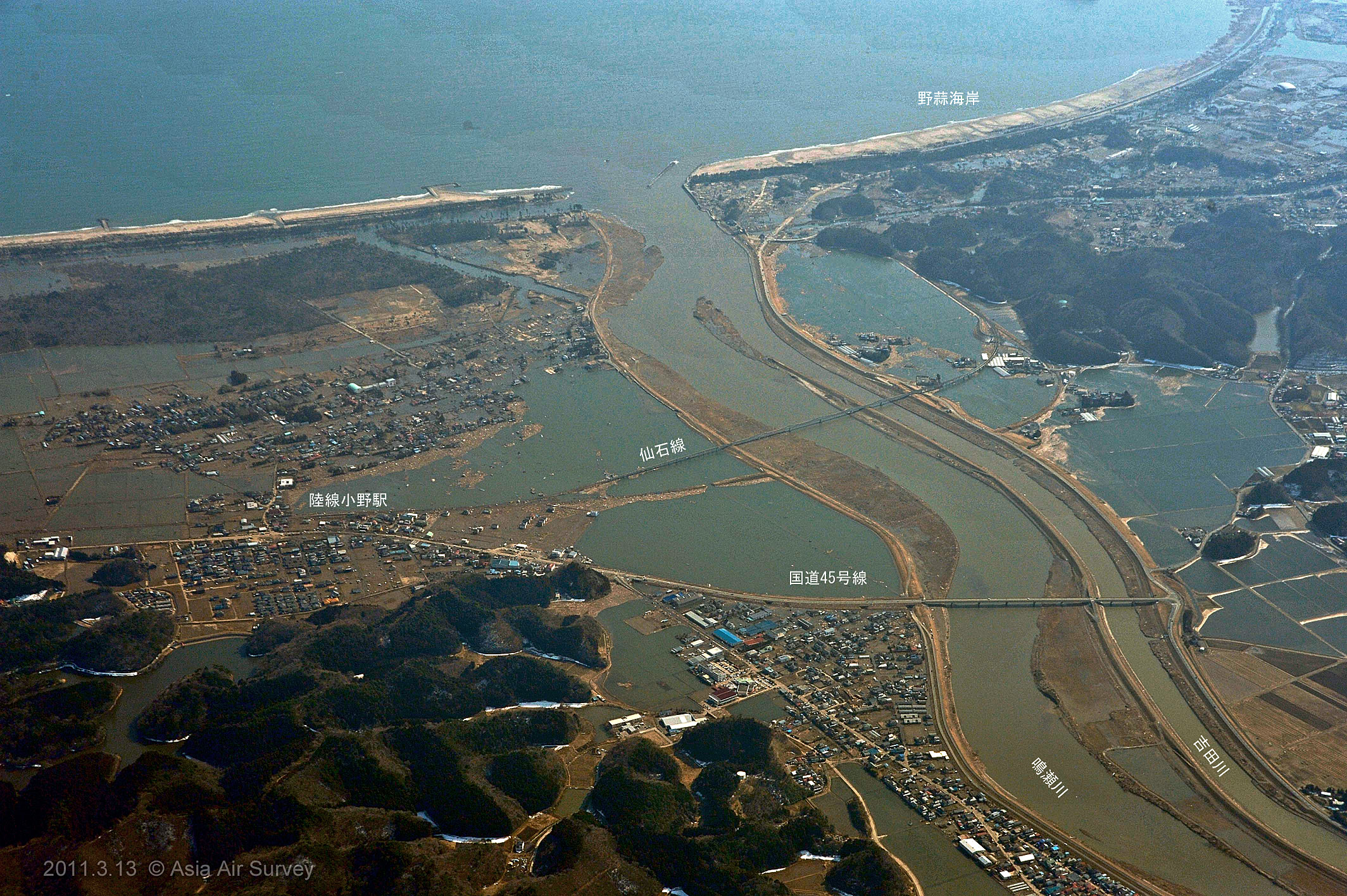
Photograph# 3.14(Shooting number _GYO1747)13:43
Rikuzen-ono station , Higashi-matsushima-city
|
|
Photograph# 3.15(Shooting number _GYO1752)13:47
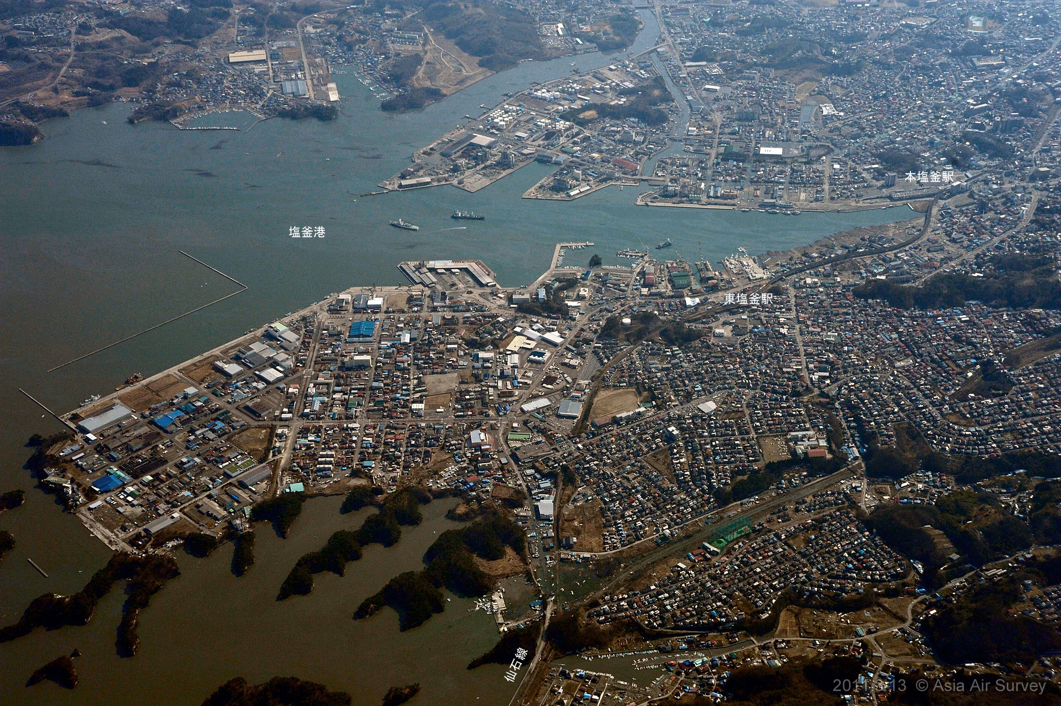
Shiogama port , Shiogama-city
|
|
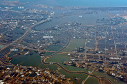
Photograph# 3.16(Shooting number _GYO1755)13:48
Sendai new port , Sendai-city
|
|
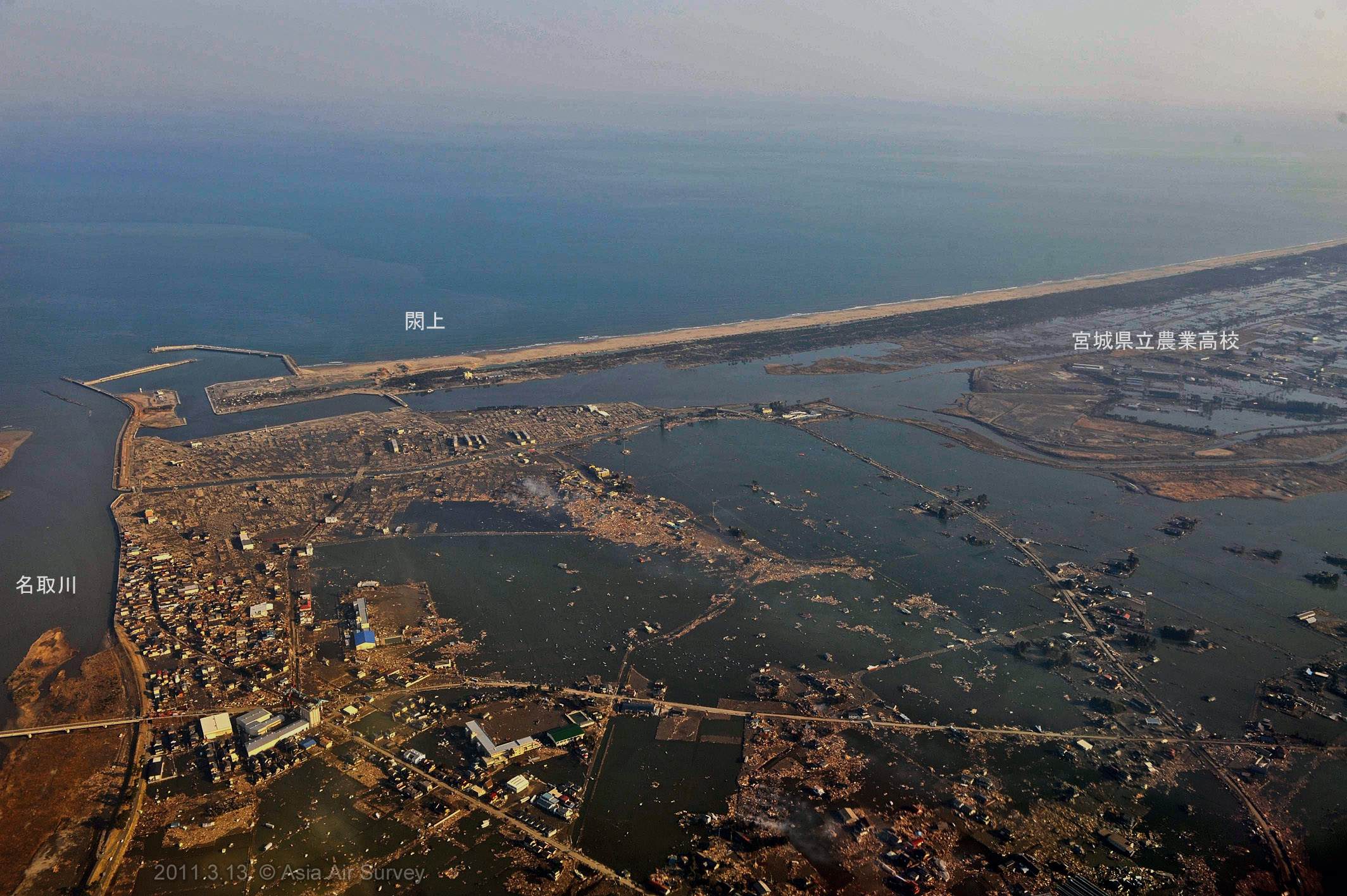
Photograph# 3.17(Shooting number _GYO2068)15:41
Natori river mouth of the river (north)
|

|
Photograph# 3.18(Shooting number _GYO2070)15:41
Nature river mouth of the river (south)
|
|
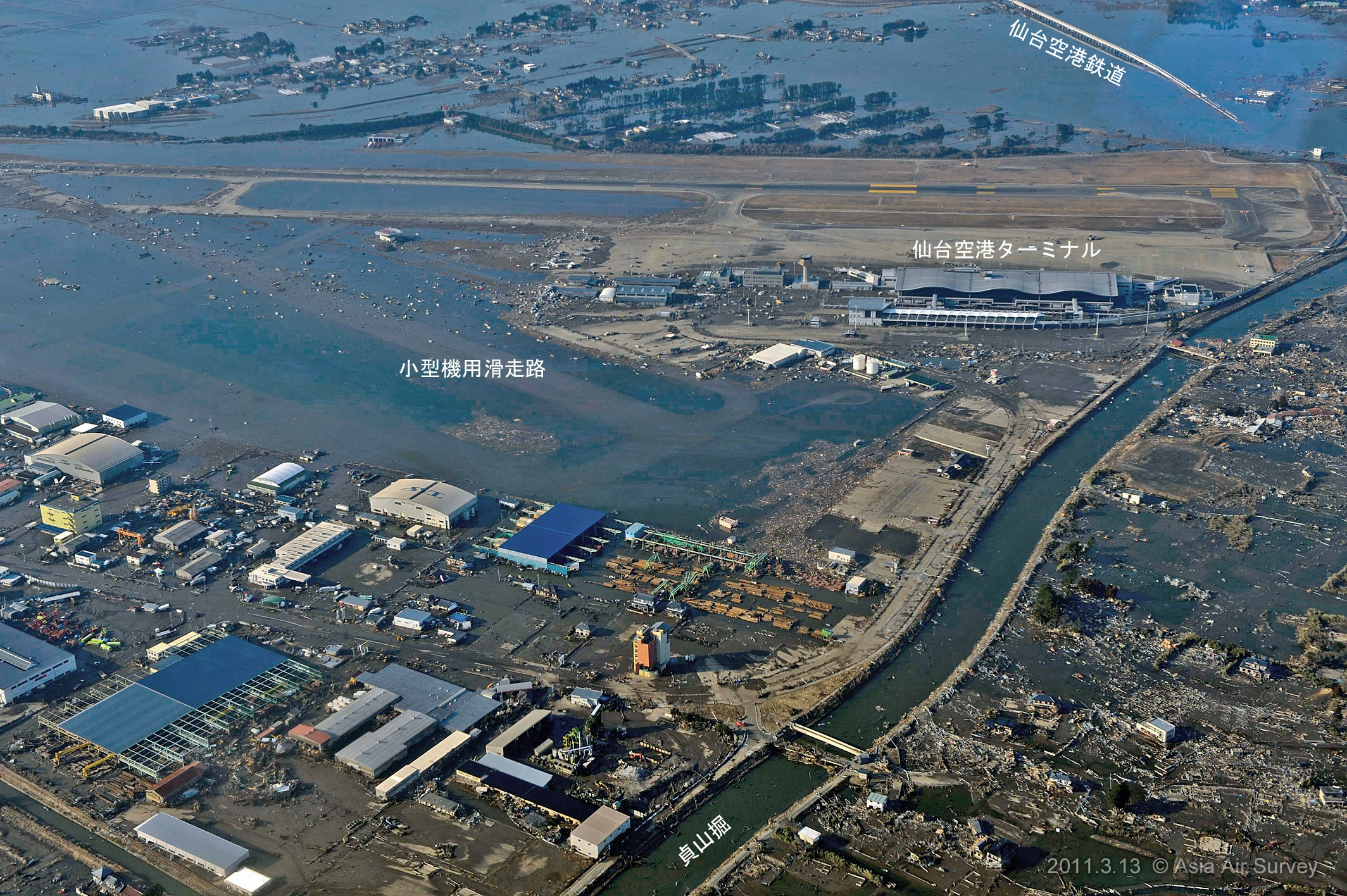
Photograph# 3.19(Shooting number _GYO2087)15:43
Sendai air port flight strip
|
|
Photograph# 3.20(Shooting number _GYO2104)15:45
Iwanuma junction
|
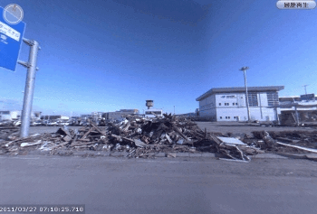
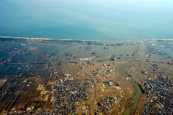
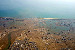
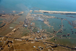
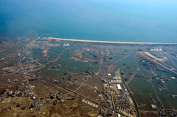
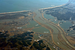
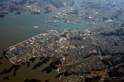
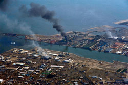
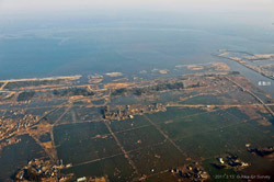
12,March, 2011 - The release of the aerial photos and associated information
|
When a large scale natural disaster occurs, Asia Air Survey immediately takes aerial photos of the stricken-areas and openly releases them to the public to assist people obtaining the accurate damage information, averting the secondary disasters, and forming the recovery plans. The details of the shooting locations of the aerial photos of this disaster have not been specified yet. However, as a way of understanding the current situation of the stricken-areas and providing additional information for the victims, their families, and others affected by the disaster, we have decided to release all the available aerial photos on-line.
We sincerely hope that these photos will help those afflicted by the disaster and lead to the prompt full recovery from the disaster.
We will continue to upload new photos once they are available.
|
|
Click here to see aerial photos
|
14,March, 2011 - Tsunami damage situation by IKONOS satellite images
Soma City and Minami Soma City, Fukushima Prefecture
|

|
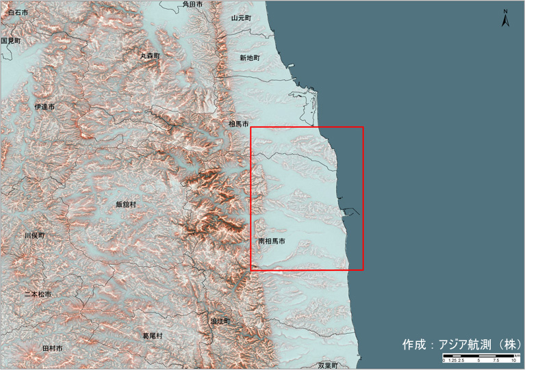
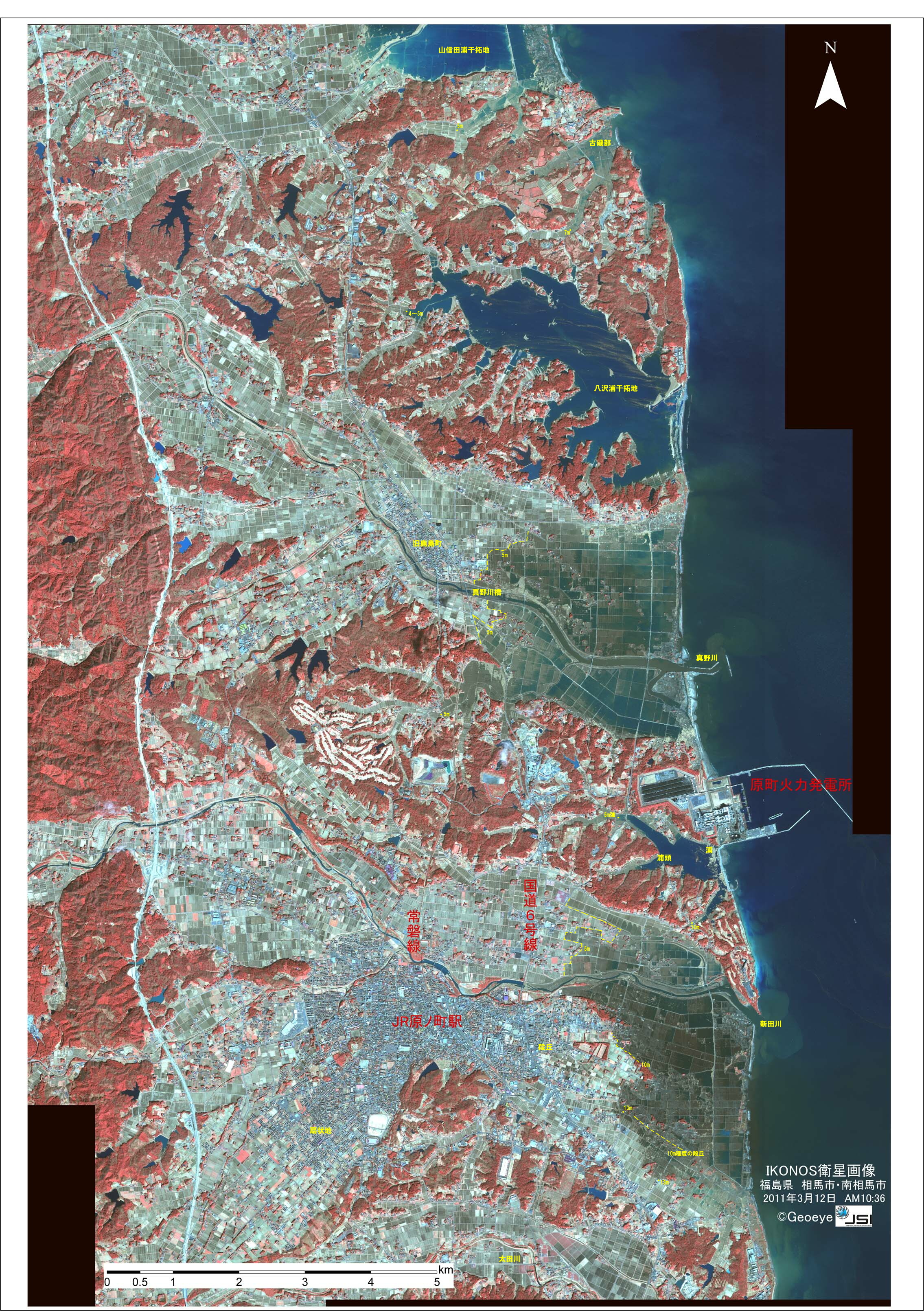
Fig. 2.1 Positional map
Using Red Relief Image Map (which was created based on the 50m mesh numeric map data from The Geospatial Information Authority of Japan) and the digital national land information administrative boundary as a background map.
|
|
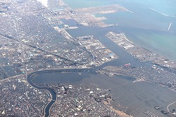
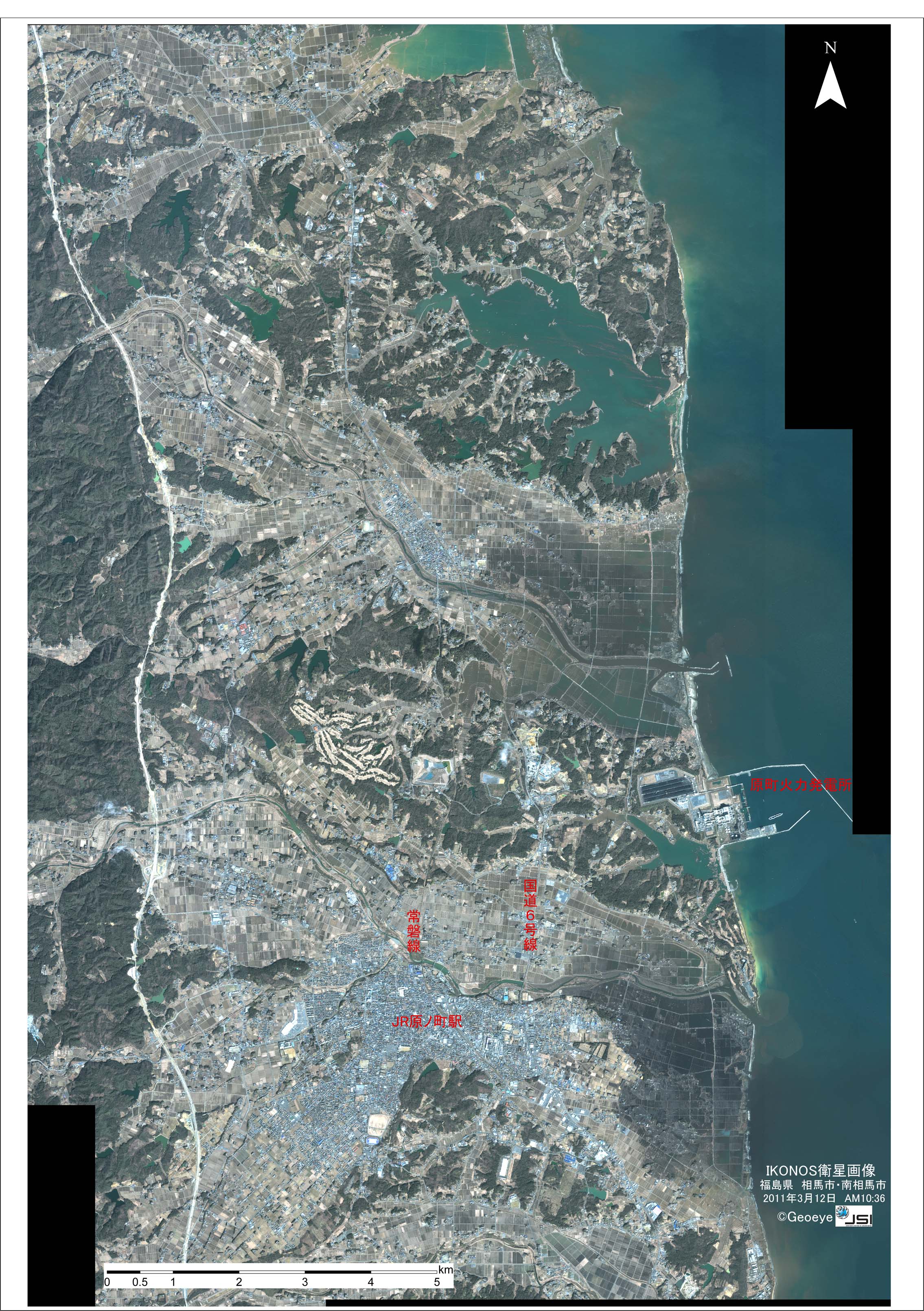
Fig. 2.2 IKONOS satellite image
Left picture: RGB color
Right picture: Infrared color
[shooting time] 10:36AM, 12 March, 2011
[Note] A top-edge of the image covers the southern part of Soma city, and the rest of the image covers Minami-Soma city. The areas where the tsunami reached and the areas where water remained at the time of shooting are drawn in a relatively dark tone and a bluish-green tone respectively.
|
|
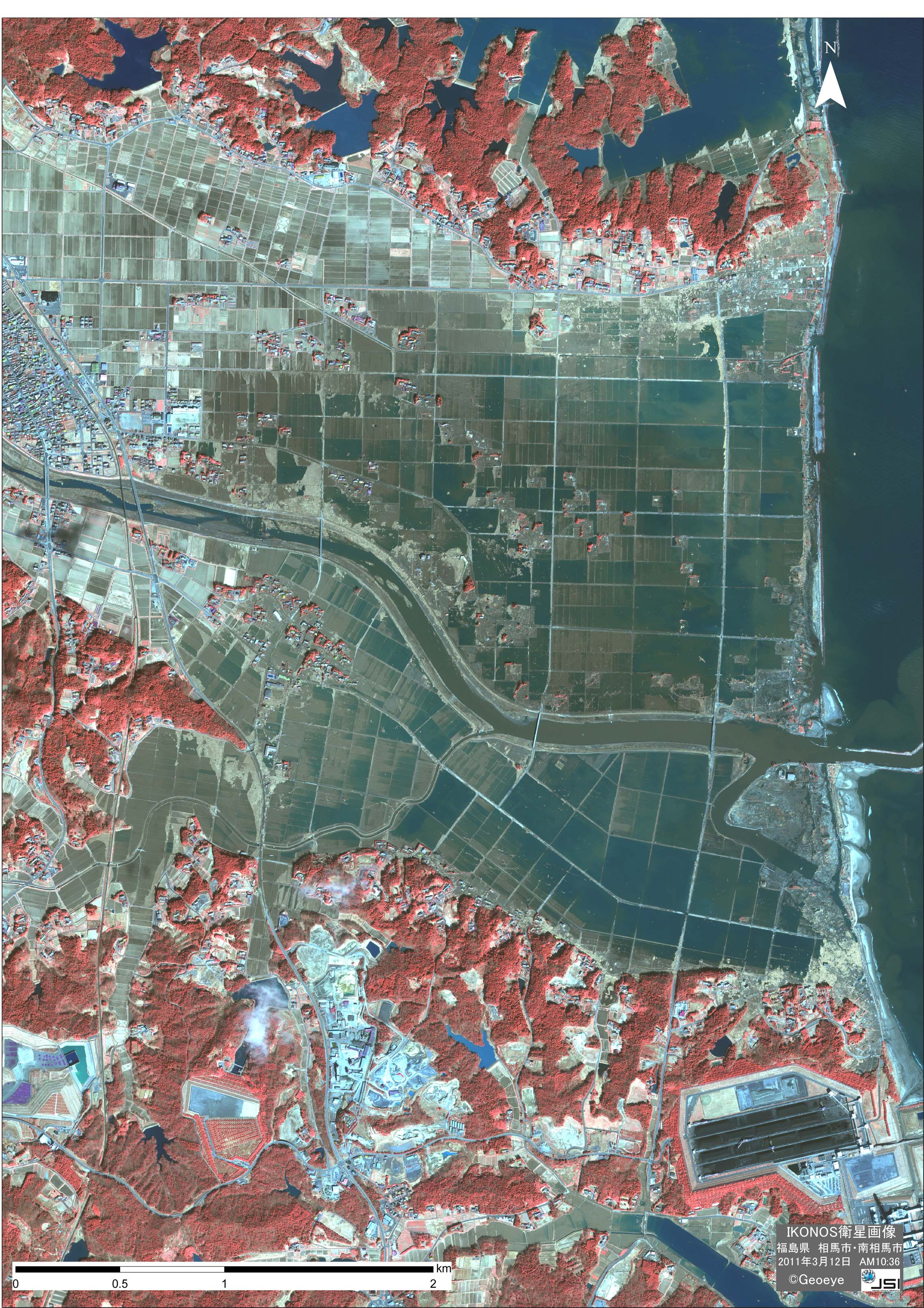
Fig. 2.3 Damage situation result
Yellow: Tsunami reached area.
Green: Tsunami reached and flooded area.
[Note] The result was obtained by analyzing the multi spectral data of IKONOS satellite images.
|
|
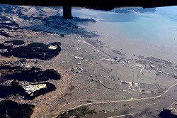
Fig. 2.4 Damage situation result (1)
In the vicinity of the Mano River, Kashima district, Minami Soma City, Fukushima prefecture.
[Note] Comparing the damage situation result and a regional terrain map published by the Geospatial Information Authority of Japan, we discovered that the tsunami had reached a height of approximately 5m around the Mano River and the low-lands north of the Nitta River.
|

|
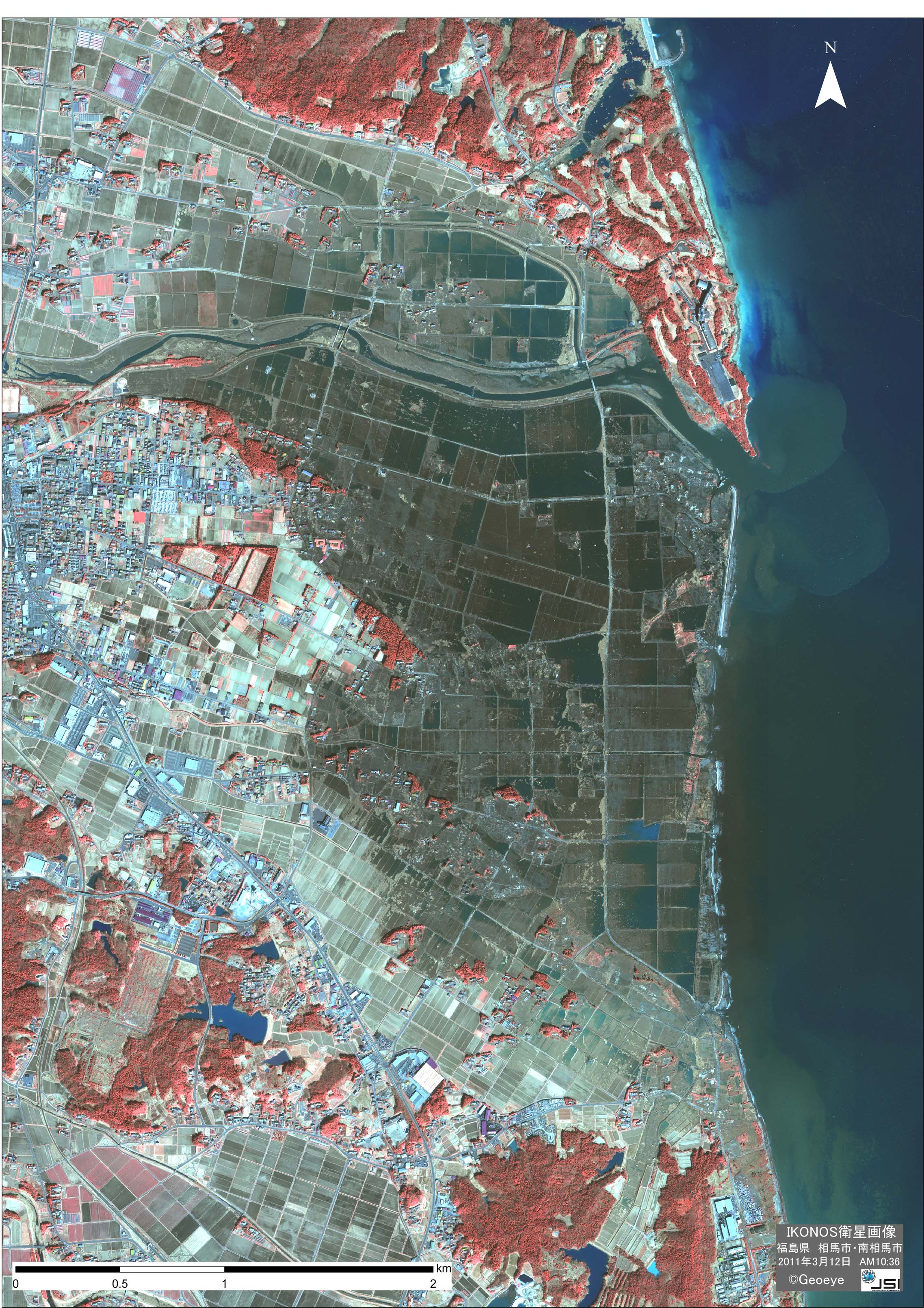
Fig. 2.5 IKONOS satellite close-up image (2) (infrared color)
In the vicinity of the mouth of the Nitta River, Ichihara-cho district, Minami Soma City, Fukushima prefecture.
Comparing the damage situation result and a regional terrain map published by the Geospatial Information Authority of Japan, we discovered that the tsunami had reached a height of approximately 13m at the south of the Nitta River.
|
-
The copyright of the satellite images above belongs to GeoEye/Japan space imaging company. Reprinting is prohibited.
-
The resultant damage situation released on this page is based solely on the information from the satellites images, and may not coincide with the current state.
|
|
Landslide triggered by the earthquake in northern part of Nagano Prefecture
|
12 March 2011, 03:59AM. Observed seismic intensities are as follows;
intensity 6 upper : Sakae-mura, Nagano prefecture,
intensity 6 lower : Tooka-machi, Niigata prefecture, and
Intensity ranging from 5 upper to 1 : Chubu area, Tohoku area, Kinki area
|
|
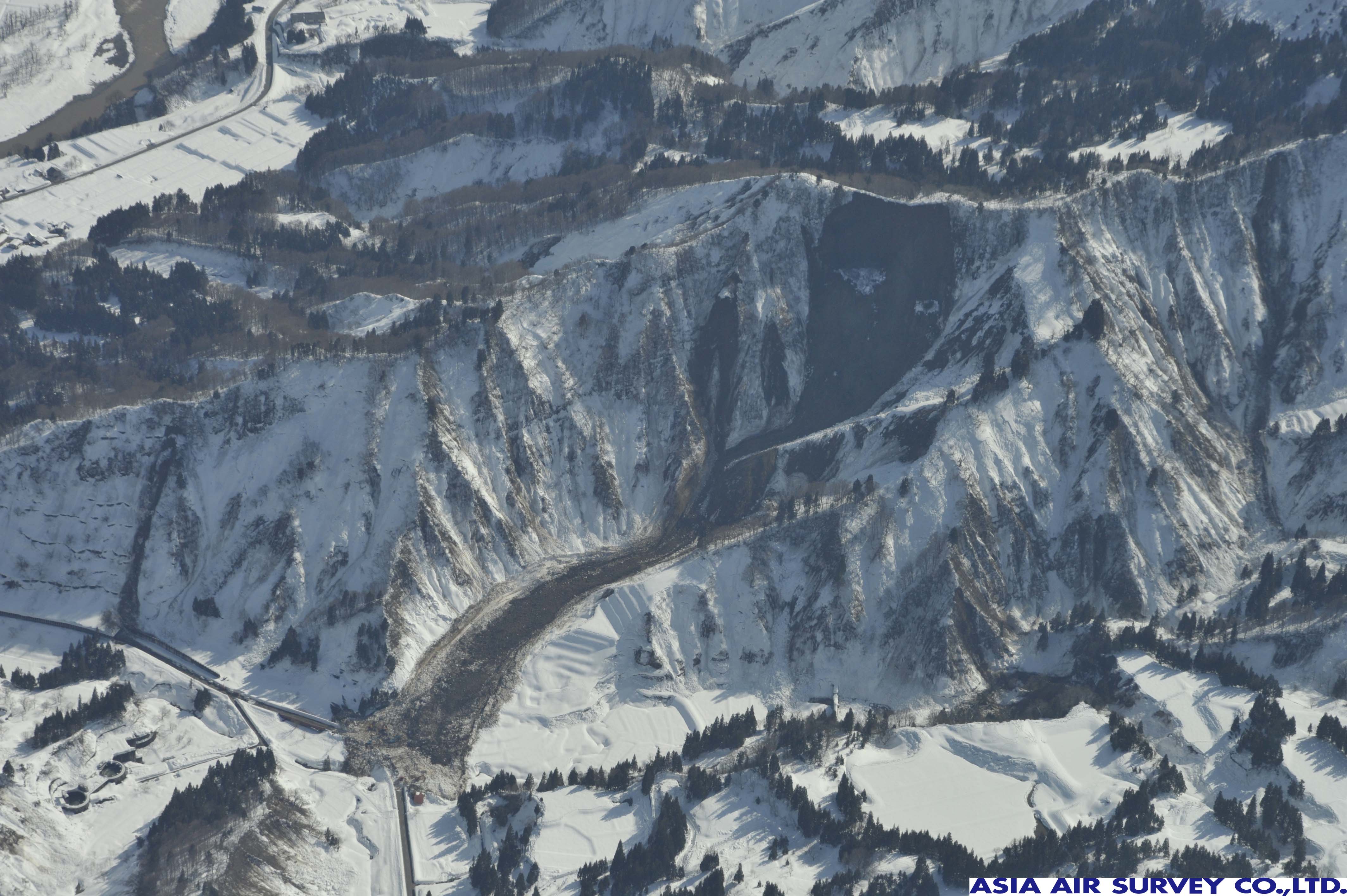
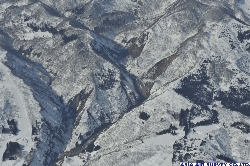
Photograph# 3.1 (Shooting number _ GYO1644)
[Shooting time] 14:42PM
Kitashin district, Sakae-mura, Nagano Prefecture.
Relatively deep landslide was triggered by the earthquake. A mixture of snow, soil, and sand slid down about 1km and reached into the Nakajo River.
|
|
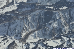
Photograph #3.2 (Shooting number _ GYO1645)
[Shooting time] 14:51PM
West side slope of Tastunoguchi district, Tsunan-machi, Niigata Prefecture.
Relatively huge landslide near the ridge line was triggered by the earthquake. Snowy mud slid down about 500m forming a snow mound and closed in to the residential site.
|
|
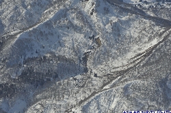
Photograph #3.3 (Shooting number _ GYO1672)
[Shooting time] 15:24PM
Occurred in Amamizu mountainside, Nagano Prefecture. A part of sediment slid down about 200m, but the great extent of the sediment remained on the slope.
|
- Information on the secondary use of images and information from this site.
All the images and information on this site are protected by the Japanese copyright laws. Thus, if you are interested in using the images provided through our webpage, please fill in the application form ( Click here to get the form) and request permission before using, reprinting, redistributing, and/or publishing any materials from this site in any form;
The application form will ask you to fill in the following information.
- Name (individual, company or organization etc.,);
- Contact Information including the address, telephone number, e-mail address and a name of a contact personnel;
- A summary explaining how the images and/or information will be used;
- The names of countries/territories where the images will be used;
After you submit the application form, written permission will be sent to you by e-mail.
If you need further information or have more questions, please do not hesitate to contact us.
For inquiries & requests, Please send an e-mail to service@ajiko.co.jp.
|
|